

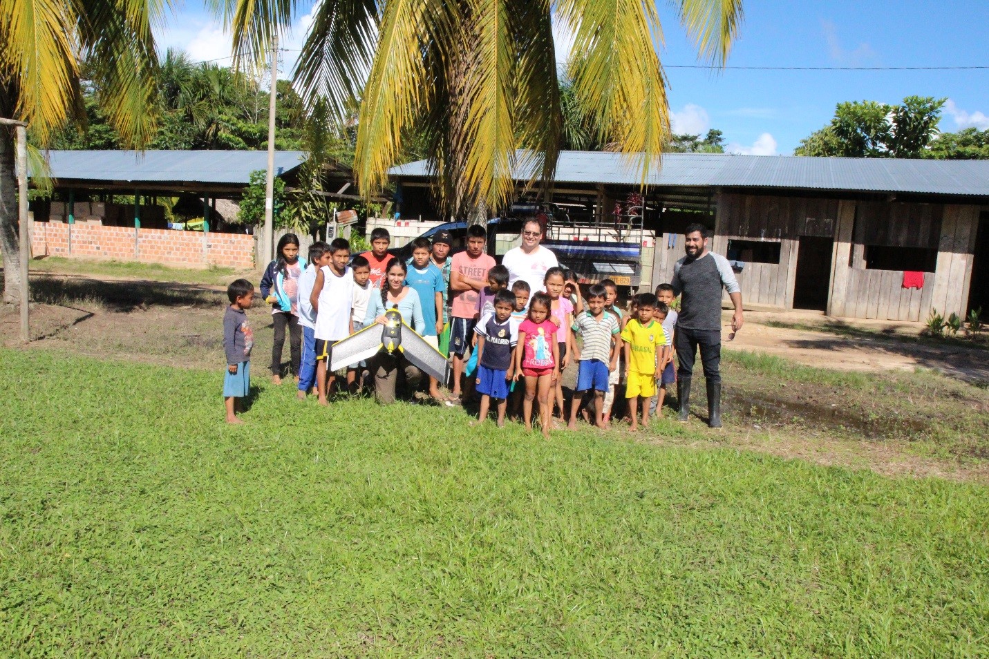
Drone monitoring of land cover changes detected by Terra-I in Yurimaguas, Peru


From May 8-12, 2017, the Terra-i team, together with staff from the DGOTA of Peru's Ministry of Environment, carried out the first field validation of vegetative land cover changes detected during Terra-i monitoring for 2016 and 2017, using the technology UAV. This work was carried out under the framework of the project “Sustainable Amazonian Landscapes”. The team carried out over-flights with a Phantom 3 advanced rotor drone and a fixed-wing Ebee drone in seven townships of Yurimaguas. The objective of this work was to recognize the dynamics of land cover and land use changes in the region while at the same time to validate the accuracy of the detections of forest loss being monitored by Terra-i in Yurimaguas.
The use of drones to monitor land cover changes
The monitoring of land cover vegetation and land use changes proves to be a theme of great interest within the field of conservation. This monitoring enables us to study the current states of highly important land covers, such as the tropical rainforest of the Amazon. The Amazonian forest has seen drastic human intervention in the last decade due to areas being cleared for continuous expansion crops, such as oil palm or rice. Currently, land cover monitoring is being carried out through satellite imagery analysis, as is the case with the Terra-i system, which uses low resolution spatial images (250 meters) of high temporality (every 16 days) in order to monitor land cover changes at the pantropical level.
In order to ensure higher reliability from the satellite image analysis, it is important to evaluate the accuracy of the detections corresponding to land cover changes by carrying out detailed in-field validation and verification processes. The Terra-i team has performed a series of in-field validations where the accuracy of the pixels of the land cover loss detected by the system was evaluated. This process consists of the random selection of a sampling of pixels, a subsequent field visit to each sub-sample corresponding to a point from the MODIS pixel (there are 9 sub-samples in an area of approximately 6 ha), followed by the taking of geo-referenced photos and implementation of surveys in order to determine the cause of the change.
These field corrections end up being time-consuming and costly, which is why UAV drones are now being used as an alternative to field validation. With a drone you can capture high quality images which are then used to validate the changes recorded by satellite, as well as to determine the type of land cover present and the area of the detected change.
The synergy between satellite image analysis, drone use and field data, together with the monitoring of regional land cover and land use change dynamics, makes it possible to evaluate the detection accuracy of a model like Terra-i and to calculate the exact area of the change in terms of pixels.
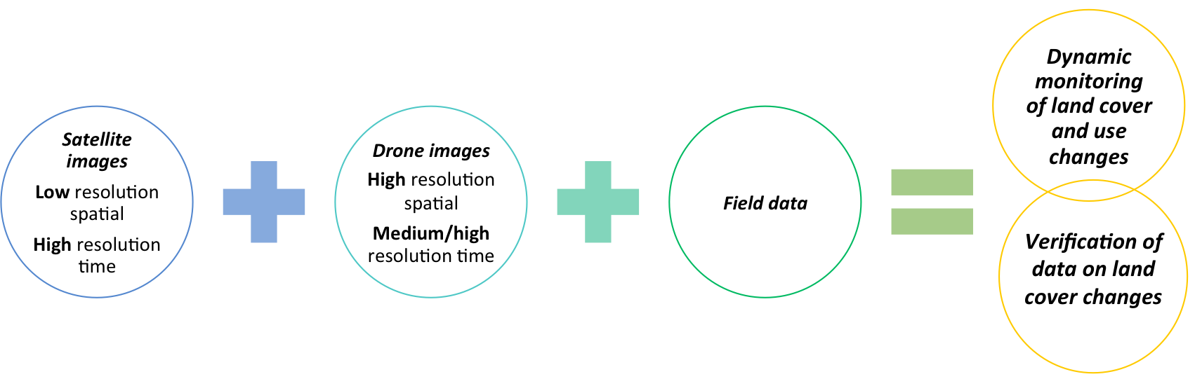
Figure 1. Use of satellite images, drones and field data to monitor land cover and change dynamics in a territory.
Field validation methodology with UAV
Equipment, sensors and software
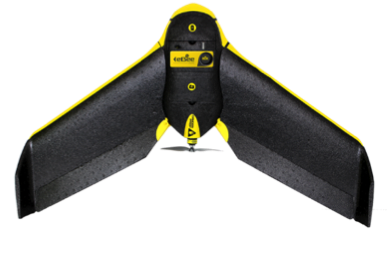 Characteristics:
Battery life: 30 [min]
Maximum speed: 40-90 [km/h]
Radio range: 4 [km]
Applications: Large-scale landscape mapping.
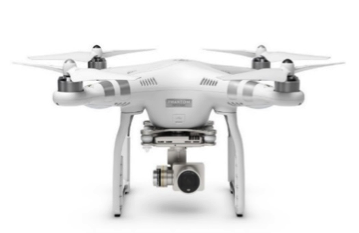 Characteristics:
Battery life: 20 [min]
Maximum speed: 25 [km/h]
Applications: Easy to launch and transport for rapid monitoring of small land plots (<25Ha) (<25Ha).
Study area
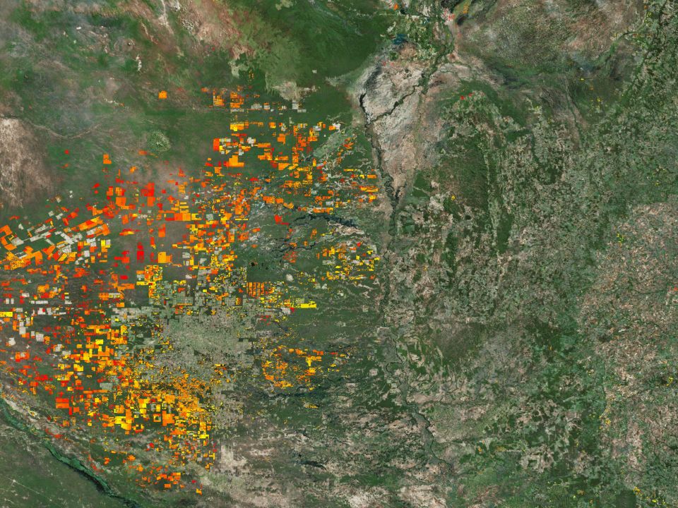
We carried out validations in the “Sustainable Amazonian Landscapes” project study site in the district of Yurimaguas, which possesses the greatest amount of land cover and land use changes within the province of Alto Amazonas (See Figure 2). This areas has accumulated 5,442 Terra-i alerts (approximately 34,012 ha) from 2004 to March of 2017, with an annual loss rate of 2,557 ha/year since 2016.
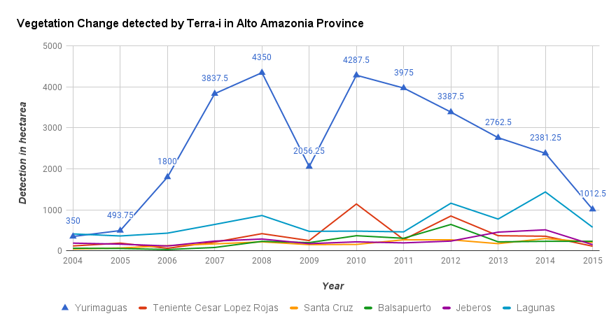
Figure 2. Land cover and land use change trends detected by Terra-I from 2004 to March 2017 for different districts of Alto Amazonas province, Loreto, Peru
Methodology
We performed 12 overflights, of which 9 were carried out with the Ebee drone (Figure 3, green stars) and 3 with the quadcopter (Figure 3, blue stars). We selected the validation areas according to the spatial distributions of the Terra-i change detections for the dates 2016-2017 in the zone. Lastly, we validated 34 alerts from 2016 and 8 from the period of 2017, equivalent to 263 ha (see the flight areas in Figure 3 map).
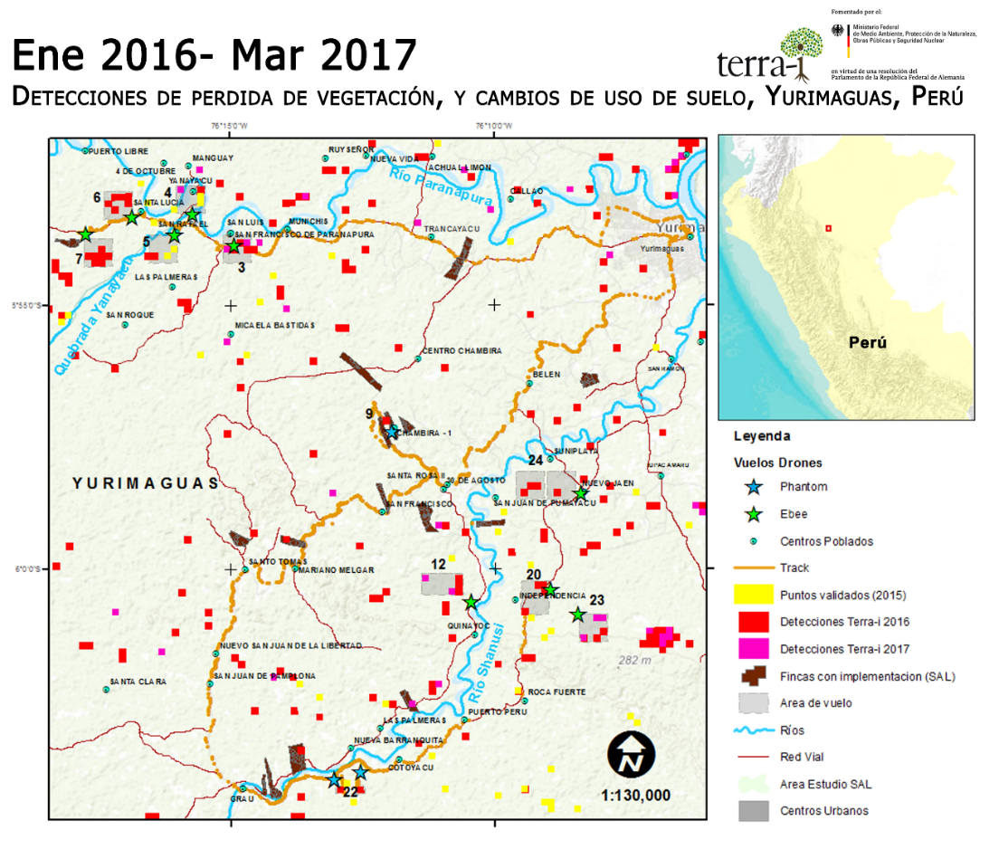
Figure 3. Flight areas completed
The aerial photographs taken were processed with Pix4d mapper software and we created georeferenced mosaics following the procedure below:
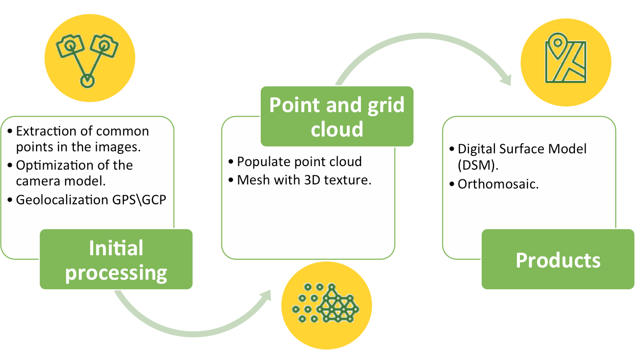
Figure 4. Drone image processing. SOURCE: PIX4D
In table 1, characteristics of each flight, number of alerts analyzed, and the resolution of mosaics processed by each drone are specified.
Table 1. Specifications of flights carried out with Ebee and Phantom 3 adv drones
|
Drone Ebee |
Drone Phantom 3 advanced |
|
Terra-i alerts: 31 (2016) , 8 (2017) Flight area: 100 – 120 ha Flight heights: 180 – 200 m Orthomosaics resolution: 5 to 7 cm/pixel |
Terra-i alerts: 3 (2016) Flight area: 25 Ha Flights heights: 60– 80 m Orthomosaic resolution: ~3 cm/pixel
|
Finally, we analyze the mosaics using the detections obtained from satellite imagery, evaluate the precision of the Terra-i detections in order to calibrate the model, and analyze the principal drivers by pixel and by area of change.
Change dynamics in Yurimaguas (Preliminary results)
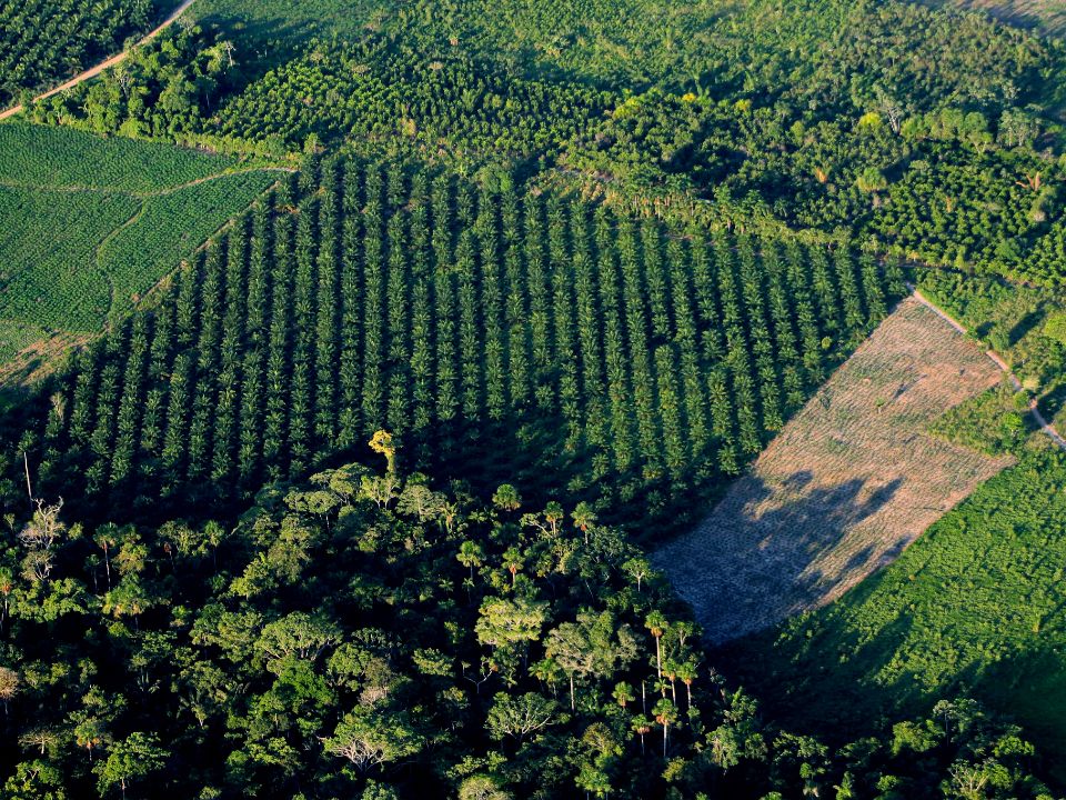
The district of Yurimaguas has seen a significant rise in the loss of land cover in 2016 at an increase of 150% since 2015. Terra-i detected a change of aproximately 3,320 ha (531 alerts) for the period of 2016 to March 2017. These changes are related to the rise in logging and burning of primary and/or secondary forests, which have been subjected to selective extraction of timber to allow for the installation of annual and permanent crops such as rice, papaya, and oil palm. The changes were encountered close to principal roadways which lead to Balsapuerto and Tarapoto, as well as along the Paranapura and Shanusi rivers.
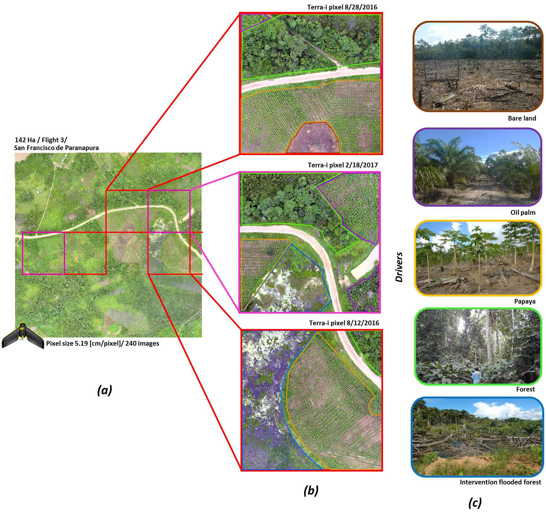
Figure 5. Flight number 3 carried out with Ebee drone close to San Francisco de Paranapura (a) Mosaic generated with drone image, with overlaid pixels for land cover changes detected by Terra-i for 2016 (red) and 2017 (pink); (b) Detailed panels of 3 Terra-i pixels from 2016 and 2017, digitization of the land cover present; (c) Photos of ‘drivers’ taken in-field during field validations from 2015 and 2017.
The changes in land cover loss detected by Terra-i were analyzed with images captured by the drones; Figure 5 shows a flight with the Ebee drone of 140 hectares, carried out close to San Francisco Paranapura, which contained 3 Terra-i detections from 2016 (red pixels) and 2 from 2017 (pink pixels). Three Terra-i detections from 2016 (2) and 2017 (1) were analyzed (each pixel is 5.3 ha), where we identified that the principal causes of the land cover changes are the implentation of papaya (>6 ha) and palm oil crops. We also observed that there were 3 ha of floodplain forests with recently installed palm trees (Aguajal), as well as bare soils as a result of logging and burning.
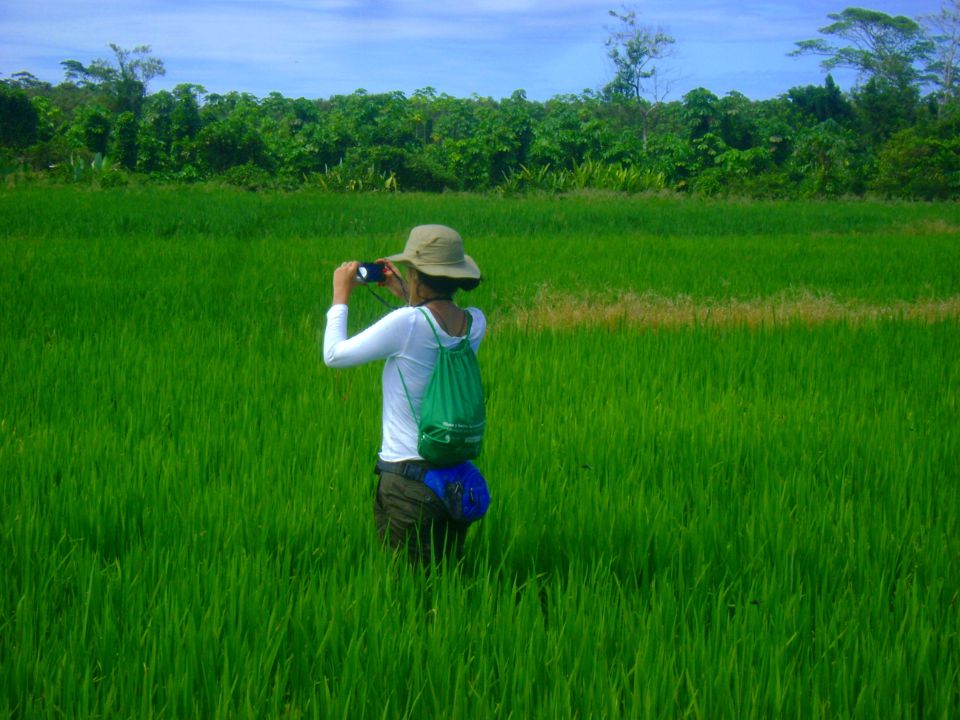
Likewise, we carried out flights in the areas of change detected by Terra-i close to the rivers, which are a result of the planting of rice crops. According to the Peruvian Ministry of Agriculture and Irrigation (MINAGRI), there was an increase of 8.2% in areas planted with rice reported in Loreto between August 2015 and June 2016, due to the farm-gate price of paddy rice increasing in this time period (Andina, 2016).
Figure 6 shows a flight of 140 ha carried out with the drone Ebee, close to the Paranapura river in Santa Lucia, which contained 6 Terra-i change detections from January to October, 2016. We analized 3 detections from January, March and April, 2016, in which we identified rice cultivation areas greater than 16 ha, floodplain forests with palm trees recently felled, bare soils and small-scale in-farm palm crops. There is also evidence of the expansion of this crop (palm) within primary forests, which are under threat.
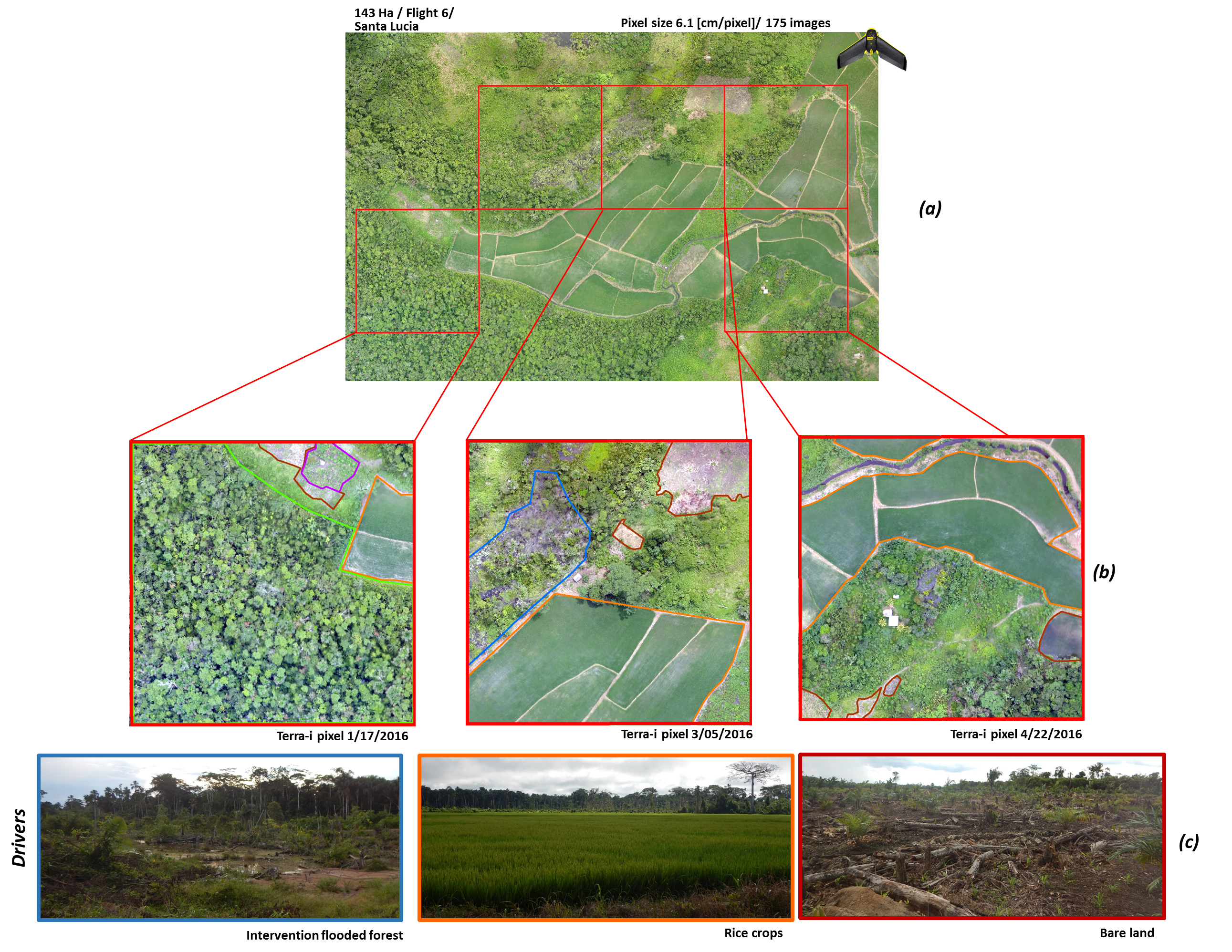
Figure 6. Flight number 6 carried out with the Ebee drone close to Santa Lucia (a) Mosaic generated with drone images, with overlaid pixels for land cover changes detected by Terra-i for 2016 (red); (b) Detailed panel of 3 Terra-i pixels from January, March, and April 2016, digitization of land cover present; (c) Photos of ‘drivers’ taken in-field during field validations from 2015 and 2017.
Economic development and human in-migration have generated an increase in the demand for land in Yurimaguas, leading to greater pressure on the primary forests for use as newly transformed areas for the implementation of subsistence and commercial agriculture. This dynamic of land cover changes tends to be more accelerated in the principal highways towards Balsapuerto and Tarapoto. Various groups of agricultural producers can be identified, taking into account their primary activity, among them are highland terrace farmers, riverside farmers, and palm cultivators.
To access the fieldwork’s photo gallery, visit the flickr account of the project “Sustainable Amazonian Landscapes” here.
We would like to thank all of those involved in the execution of the fieldwork. This work has been carried out as part of the project “Sustainable Amazonian Landscapes” which is financed by the International Climate Initiative (IKI). The project is led by CIAT and implemented together with the Potsdam Institute for Climate Impact (PIK), the Centro para la Investigación en Sistemas Sostenibles de Producción Agropecuaria (CIPAV), Instituto Amazónico de Investigaciones Científicas SINCHI, Universidad de la Amazonía, Instituto de Investigaciones de la Amazonía Peruana (IIAP), and the Universidad Nacional Agraria La Molina (VLIR-UNALM).
Written by: Paula Andrea Paz.
English version prepared by Natalie Orentlicher (CIAT).
Originally Posted by https://amazonlandscapes.org
References
Kakaes, K., Greenwood, F., Lippincot, M., Meier, P., Wich, S.2015. Drones and aerial observation:new technologies for property rights, human rights, and global development a primer. Chapter 7: 63.
Haarpaintner, J., et al. 2014. Validation of optical and SAR satellite-based forest maps with field data in the Mai Ndombe district, Dem. Rep. of Congo. Conference Paper ForestSAT 2014.
Andina. 2016. Minagri: Producción de arroz creció 3.5% en primer semestre del año. Agencia peruana de noticias Andina.


The Terra-i team together with CRS El Salvador under the Raices project carried out a virtual workshop through the teams platform to technicians from the Ministry of Environment and Natural Resources, CARITAS, Universidad El Salvador, CENTA, about the Mapping of land cover using remote sensors and open source tools such as GEE, SEPAL and QGIS- Plugin Semi Automatic Classification.


Near real-time vegetation loss detection in Southwestern Ethiopia: calibration, validation, and implementation of the Terra-i system


The Alliance of Bioversity International and the International Center for Tropical Agriculture (CIAT) (the Alliance) conducted a training for local stakeholders on the use of Terra-i as part of the collaboration with the Netherlands Development Organisation – SNV in the Coffee Agroforestry and Forest Enhancement for REDD+ (CAFÉ-REDD) Project.


IDENTIFICACIÓN DE CAUSAS DE PÉRDIDA DE COBERTURA VEGETAL EN LAS ÁREAS DE INTERVENCIÓN DE LA ACTIVIDAD GOBERNANZA EN ECOSISTEMAS, MEDIOS DE VIDA Y AGUA (USAID/GEMA) EN EL OCCIDENTE DE HONDURAS

MAPEO DE COBERTURAS DE LA TIERRA PARA EL 2017, EN EL OCCIDENTE HONDUREÑO SOBRE ÁREAS DE INTERVENCIÓN DE LA ACTIVIDAD GOBERNANZA EN ECOSISTEMAS, MEDIOS DE VIDA Y AGUA (USAID/GEMA)
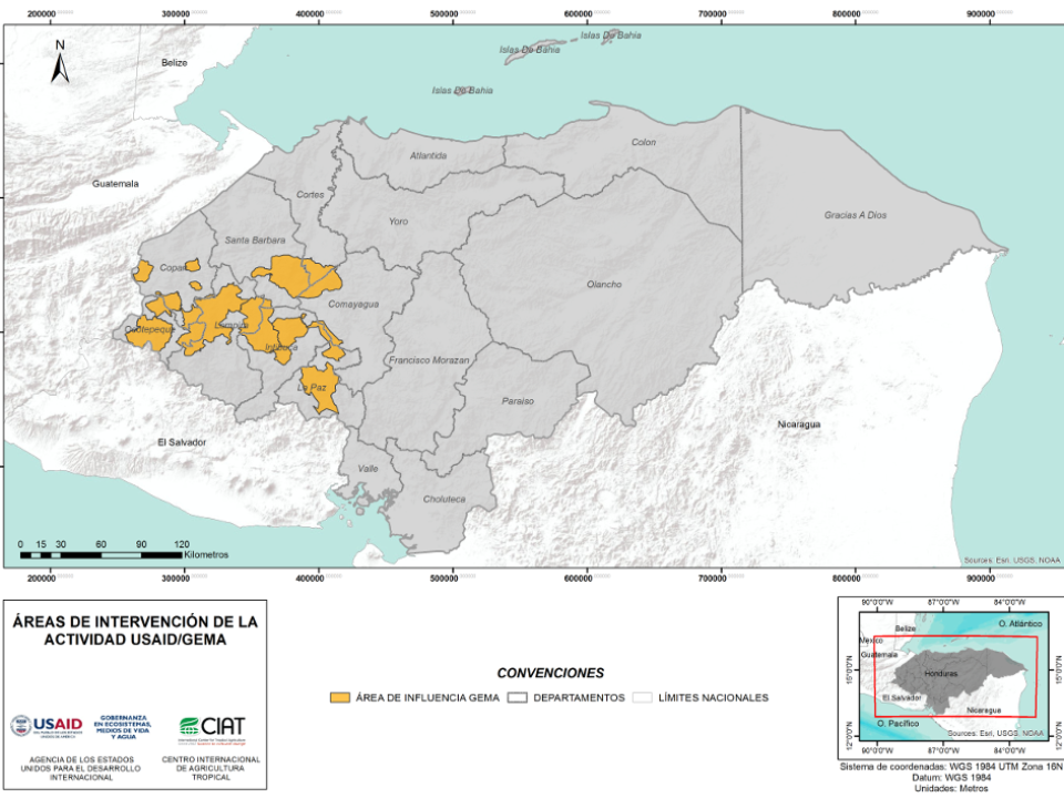

CUANTIFICACIÓN DE LA DEFORESTACIÓN EN LAS ÁREAS DE INTERVENCIÓN DE LA ACTIVIDAD GOBERNANZA EN ECOSISTEMAS, MEDIOS DE VIDA Y AGUA (USAID/GEMA) EN EL OCCIDENTE DE HONDURAS

An international team of scientists*, involving entomologists, conservation biologists, agro-ecologists and geographers, has just revealed how on-farm insect biological control can slow the pace of tropical deforestation and avert biodiversity loss on a macro-scale. The case study concerns biological control of the invasive mealybug Phenacoccus manihoti with the introduced host-specific parasitic wasp Anagyrus lopezi in Southeast Asia. The results of this study have just been published in Communications Biology – Nature.

CIAT and the Terra-i team are pleased to announce the publication of a new study in Paraquaria Natural, the most prestigious journal in Paraguay dedicated to biodiversity and the conservation of nature.


The Terra-i team has worked hard on renovating Terra-i’s website since early this year. A set of new features on the website provides interactive contents and facilitates adaptation to the mobile devices of our users. The fresh website was developed using the latest update of an open-source, Java-based web system, Magnolia CMS 5.4.4. This update was customized to add different categories of interaction such as news, vegetation cover changes, and information, among others.


Globally more than 1 billion people depend on forests for their livelihoods. Forests play a crucial role in climate regulation, ecosystem services provision and regulation, water supply, carbon storage and many other functions that support biodiversity. Currently the global rate of deforestation is substantial, and there is a growing need for timely, spatially explicit data that flag natural vegetation changes due to human activities.
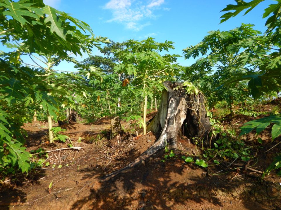

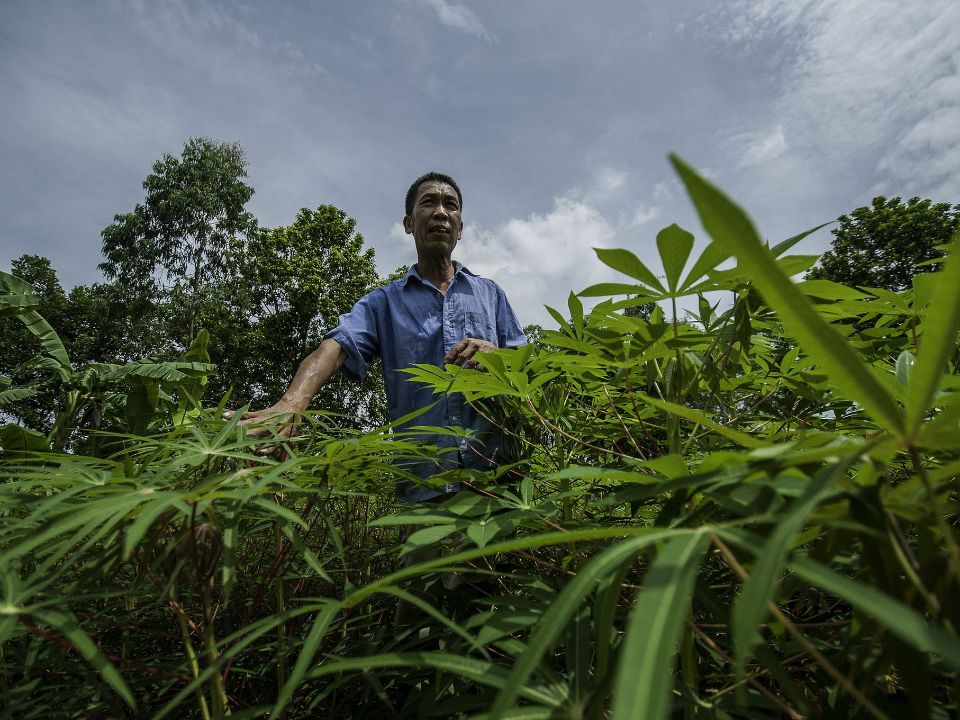
New deforestation hotspots point the finger at my favourite fruit I love Terra-i, but today I hate it. A lot. The system uses satellite images to track deforestation in the Amazon in near-realtime. It’s extremely accurate: if a bunch of trees come down somewhere – no matter how remote – Terra-i picks it up. Cool, right? Not today. CIAT’s Louis Reymondin, the system’s chief architect, dropped the bombshell over coffee: it looks as though hundreds of hectares of rainforest in Peru are being trashed by… papaya.


The latest update of Terra-i has been used with the Co$ting Nature ecosystem services assessment tool to understand the impacts of recent forest loss in Colombia on biodiversity and ecosystem services.

The production of geospatial data related to land-use and land cover changes by governments and civil society organizations has vastly increased during the last decade. Going beyond the valuable information (location, rates and absolute values of changes) provided by these datasets, it is important to have a better understanding of the spatial configurations and composition of the detected change areas at multiple spatial resolutions and time periods. Alejandro Coca-Castro’s research is aiming to map types of spatial deforestation patterns in the Amazon rainforest through the integration of landscape fragmentation metrics and data mining techniques. The research will contribute to the understanding of two deforestation datasets (Terra-i and GFC) and is part of his master dissertation at King’s College London. This blog post highlights Alejandro’s research methodology, preliminary findings and challenges.

Ecuador is recognized as one of the biodiverse hotspots on earth, underneath the Amazon rainforest lies the country’s oil reservoir. With the oil companies and cleared routes come settlers, therefore more and more of this diverse rainforest is being cut down. Since the oil concerns entered the Ecuadorian Amazon 45 years ago, they keep exploring and exploiting the area. The Terra-i detections reveal a total habitat loss of 87,525 Ha, 16,943 Ha (19%) is part of protected areas, between January 2004 and February 2015.
The Terra-i team together with CRS El Salvador under the Raices project carried out a virtual workshop through the teams platform to technicians from the Ministry of Environment and Natural Resources, CARITAS, Universidad El Salvador, CENTA, about the Mapping of land cover using remote sensors and open source tools such as GEE, SEPAL and QGIS- Plugin Semi Automatic Classification.
Near real-time vegetation loss detection in Southwestern Ethiopia: calibration, validation, and implementation of the Terra-i system
The Alliance of Bioversity International and the International Center for Tropical Agriculture (CIAT) (the Alliance) conducted a training for local stakeholders on the use of Terra-i as part of the collaboration with the Netherlands Development Organisation – SNV in the Coffee Agroforestry and Forest Enhancement for REDD+ (CAFÉ-REDD) Project.
The Terra-i team has worked hard on renovating Terra-i’s website since early this year. A set of new features on the website provides interactive contents and facilitates adaptation to the mobile devices of our users. The fresh website was developed using the latest update of an open-source, Java-based web system, Magnolia CMS 5.4.4. This update was customized to add different categories of interaction such as news, vegetation cover changes, and information, among others.
Globally more than 1 billion people depend on forests for their livelihoods. Forests play a crucial role in climate regulation, ecosystem services provision and regulation, water supply, carbon storage and many other functions that support biodiversity. Currently the global rate of deforestation is substantial, and there is a growing need for timely, spatially explicit data that flag natural vegetation changes due to human activities.
The latest update of Terra-i has been used with the Co$ting Nature ecosystem services assessment tool to understand the impacts of recent forest loss in Colombia on biodiversity and ecosystem services.

During the 1st and 12th of June 2015, the Terra-i team, together with the Instituto de Investigaciones de la Amazonía Peruana (IIAP) and the Universidad Nacional Agraria La Molina (VLIR-UNALM), conducted the second field validation of the data produced by the Terra-I system. This time, the study area was the Yurimaguas district, Alto Amazonas province, Loreto region (Peru). We used information on populated places, main roads, rivers and information on land cover changes detected for 2013, 2014 and 2015 to define the 65 sampling points (or Terra-I pixels) for the validation process (Figure 1).