
An inconvenient ground-truth


New deforestation hotspots point the finger at my favourite fruit I love Terra-i, but today I hate it. A lot. The system uses satellite images to track deforestation in the Amazon in near-realtime. It’s extremely accurate: if a bunch of trees come down somewhere – no matter how remote – Terra-i picks it up. Cool, right? Not today. CIAT’s Louis Reymondin, the system’s chief architect, dropped the bombshell over coffee: it looks as though hundreds of hectares of rainforest in Peru are being trashed by… papaya.
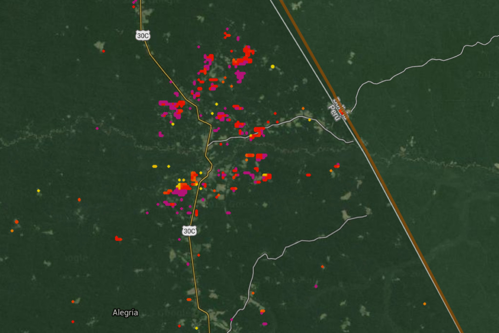
Screengrab of deforestation hotspots in Madre De Dios, Peru, from Terra-i.
It was one of those heart-sinking moments, when you have to fundamentally re-evaluate something you hold dear. Like when Jamiroquai started making bland pop music instead of space-funk. Or when Volkswagen was outed for bluffing emissions tests.
This morning I just wasn’t ready to add papaya to my list of fallen idols.
As far as I was concerned, the fruit was a keeper. I munch through at least one of those plump, sumptuous, rugby balls of joy every week. Even if I’m not buying, I could spend hours at the papaya stand in the market, just squeezing the fruits, feeling how much the flesh yields – an indicator of their readiness for total, dribbling devourment.
Louis, please not papaya. Seriously.
The thing with Terra-i is that it doesn’t lie. Two years of cross-checking what the satellite images show with what’s happening on the ground means it’s the best near-realtime deforestation monitoring system around.
Unfortunately for me, it was one of these “ground-truthing” exercises that spilled the beans on papaya.
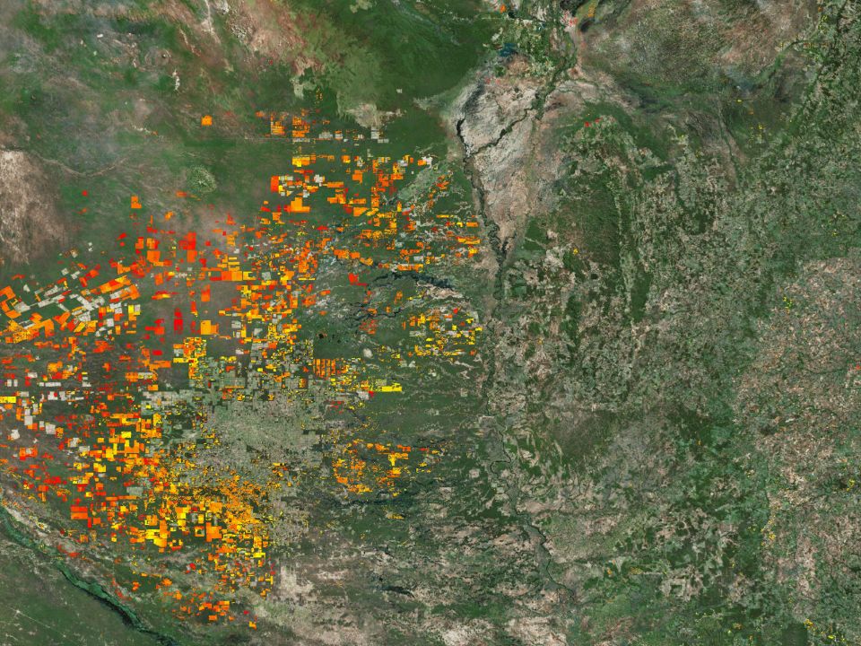
It started a few months back, when the Terra-i team discovered hotspots of new forest clearance in the Peruvian Amazon. The satellite images showed red and purple freckles in a sea of green. To trained eyes, this didn’t look like oil palm, ranching or mining – common causes of deforestation in the region.
Intrigued, the team joined Peru’s Ministry of Environment (MINAM) – which uses Terra-i as its official deforestation monitoring tool – to go and take a look.
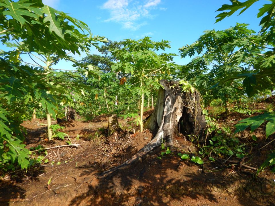
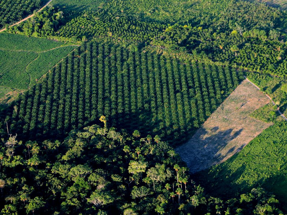
You can probably guess what they saw when they arrived in Yurimaguas, in the country’s northeastern Amazon: papaya trees. Lots of them. Large areas of forest had been cleared to make way for plantations. While initially surprised, the team thought it might be a one-off, a localised incident.
But several hundred kilometres southeast in Madre De Dios state, they saw the same thing: new deforestation on the map, and on the ground, papaya. In Pucallpa in the centre of Peru, still more.
It was starting to look like a troubling trend: papaya was becoming a deforestation driver. Thanks Louis; thanks Terra-i. You just rained on my papaya parade.
Pic by Terra-i CIAT. Papaya plantations in the Peruvian Amazon.
This inconvenient ground-truth forced me to reconsider my allegiance to my favourite fruit. I picked apart all of the assumptions that had led me to love it so much. But beyond its fabulous flavour and compulsive squeeziness, I realised I didn’t know much for certain.
For example, I’d never given much thought as to where and how papaya is grown. On numerous occasions I’d seen individual trees in home gardens across the tropics, often within reaching distance of the kitchen. Foolishly, it had never struck me as a plantation crop.
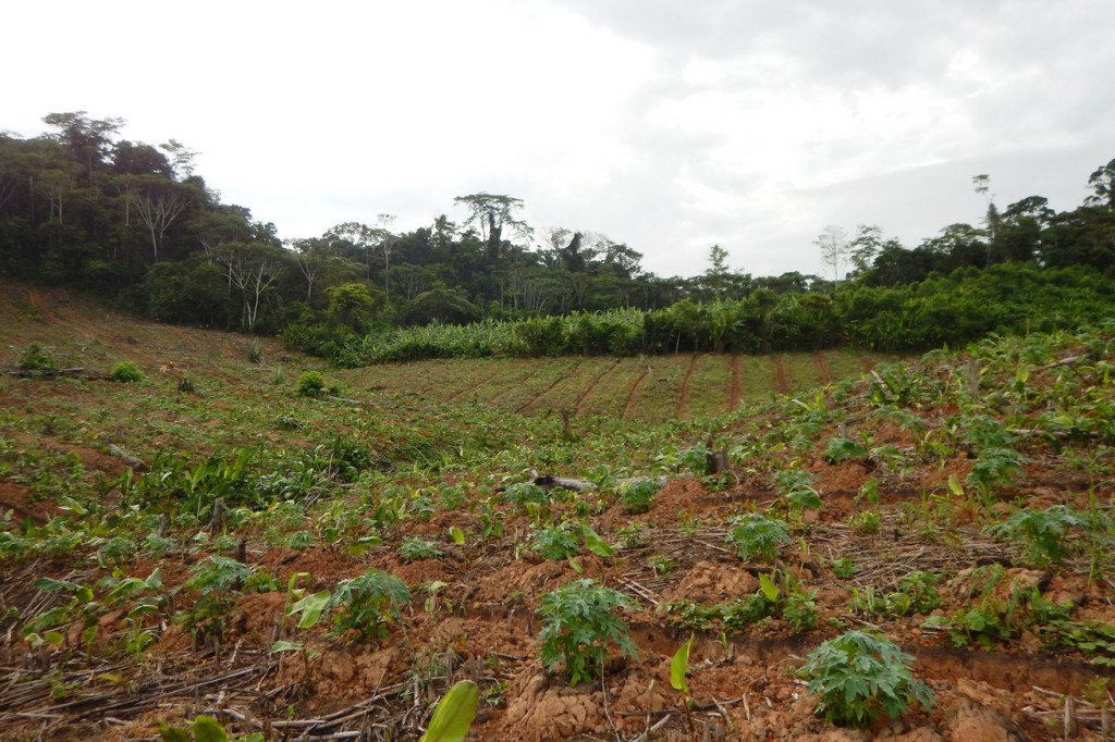
And as it turns out, papaya’s environmental credentials – if it’s grown as a monoculture – are quite damning. Louis explained what typically happens: first you clear the land of those pesky trees, then you plant. In two-to-three years you’ll get fruit; but after only a few harvests the trees are exhausted and so is the soil. Before you can plant again, the land has to rest for at least a year. While you wait – you guessed it – you might as well clear a tract of forest nearby and plant more papaya.
That said, all plantation crops have the potential to cause environmental havoc so it’s unfair to pillory papaya in particular. There’s also a lot more we need to understand about papaya-driven deforestation. The team heard that human migration is probably partly to blame: with life in Peru’s high plains so unforgiving for many people, Altiplaneros are moving to the fertile forests downhill. Papaya is a popular choice because harvested fruits are relatively easy to transport and require zero processing. Prices are good too: at the moment, a medium-sized papaya in Lima can retail for as much as USD$2 and there’s also a vibrant export market.
At the very least, the ability to quickly spot new papaya plantations with the help of Terra-i means MINAM has a better idea of what’s going on. And in terms of the total area affected, Louis assures me that tree-felling for papaya is still just a blip on the radar in Peru. Oil palm and livestock remain major culprits, accounting for thousands rather than hundreds of hectares of cleared land, he says.
But what intrigues him about papaya is that, right now, we don’t know where we are on the trajectory. There’s no doubt that papaya-related land clearance in the Amazon has exploded since 2014, while tree-cutting for crops like oil palm has remained more-or-less stable.
Is papaya really becoming a new bad kid on the block, or is this just a flash in the pan? At the moment that’s up for grabs, but whatever happens next, Louis and the Terra-i team will probably be the first to know.
*
CIAT’s work on Terra-i is funded by the World Resources Institute and the CGIAR Research Program on Forests, Trees and Agroforesty.
Originally Posted on CIAT Blog News : http://www.ciatnews.cgiar.org/2015/11/17/get-your-hands-off-my-papaya-louis/

IDENTIFICACIÓN DE CAUSAS DE PÉRDIDA DE COBERTURA VEGETAL EN LAS ÁREAS DE INTERVENCIÓN DE LA ACTIVIDAD GOBERNANZA EN ECOSISTEMAS, MEDIOS DE VIDA Y AGUA (USAID/GEMA) EN EL OCCIDENTE DE HONDURAS
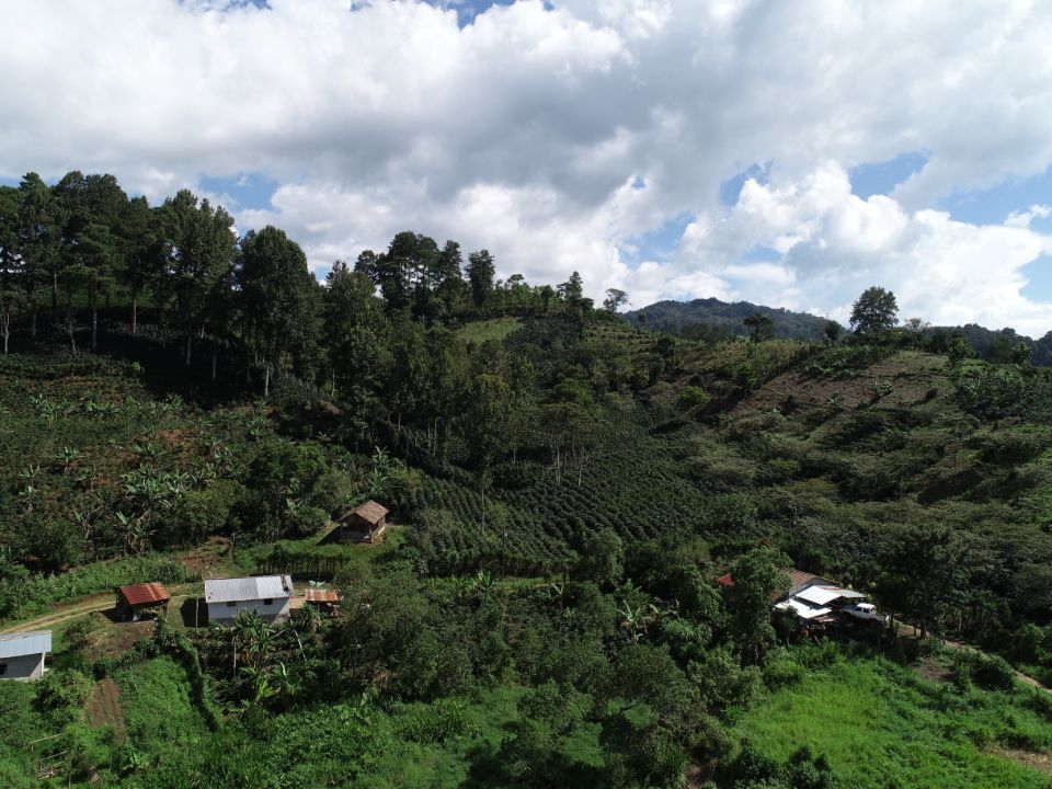

MAPEO DE COBERTURAS DE LA TIERRA PARA EL 2017, EN EL OCCIDENTE HONDUREÑO SOBRE ÁREAS DE INTERVENCIÓN DE LA ACTIVIDAD GOBERNANZA EN ECOSISTEMAS, MEDIOS DE VIDA Y AGUA (USAID/GEMA)
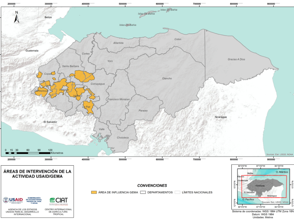

CUANTIFICACIÓN DE LA DEFORESTACIÓN EN LAS ÁREAS DE INTERVENCIÓN DE LA ACTIVIDAD GOBERNANZA EN ECOSISTEMAS, MEDIOS DE VIDA Y AGUA (USAID/GEMA) EN EL OCCIDENTE DE HONDURAS

An international team of scientists*, involving entomologists, conservation biologists, agro-ecologists and geographers, has just revealed how on-farm insect biological control can slow the pace of tropical deforestation and avert biodiversity loss on a macro-scale. The case study concerns biological control of the invasive mealybug Phenacoccus manihoti with the introduced host-specific parasitic wasp Anagyrus lopezi in Southeast Asia. The results of this study have just been published in Communications Biology – Nature.

CIAT and the Terra-i team are pleased to announce the publication of a new study in Paraquaria Natural, the most prestigious journal in Paraguay dedicated to biodiversity and the conservation of nature.

The production of geospatial data related to land-use and land cover changes by governments and civil society organizations has vastly increased during the last decade. Going beyond the valuable information (location, rates and absolute values of changes) provided by these datasets, it is important to have a better understanding of the spatial configurations and composition of the detected change areas at multiple spatial resolutions and time periods. Alejandro Coca-Castro’s research is aiming to map types of spatial deforestation patterns in the Amazon rainforest through the integration of landscape fragmentation metrics and data mining techniques. The research will contribute to the understanding of two deforestation datasets (Terra-i and GFC) and is part of his master dissertation at King’s College London. This blog post highlights Alejandro’s research methodology, preliminary findings and challenges.

Ecuador is recognized as one of the biodiverse hotspots on earth, underneath the Amazon rainforest lies the country’s oil reservoir. With the oil companies and cleared routes come settlers, therefore more and more of this diverse rainforest is being cut down. Since the oil concerns entered the Ecuadorian Amazon 45 years ago, they keep exploring and exploiting the area. The Terra-i detections reveal a total habitat loss of 87,525 Ha, 16,943 Ha (19%) is part of protected areas, between January 2004 and February 2015.


The Terra-i team together with CRS El Salvador under the Raices project carried out a virtual workshop through the teams platform to technicians from the Ministry of Environment and Natural Resources, CARITAS, Universidad El Salvador, CENTA, about the Mapping of land cover using remote sensors and open source tools such as GEE, SEPAL and QGIS- Plugin Semi Automatic Classification.


Near real-time vegetation loss detection in Southwestern Ethiopia: calibration, validation, and implementation of the Terra-i system


The Alliance of Bioversity International and the International Center for Tropical Agriculture (CIAT) (the Alliance) conducted a training for local stakeholders on the use of Terra-i as part of the collaboration with the Netherlands Development Organisation – SNV in the Coffee Agroforestry and Forest Enhancement for REDD+ (CAFÉ-REDD) Project.


IDENTIFICACIÓN DE CAUSAS DE PÉRDIDA DE COBERTURA VEGETAL EN LAS ÁREAS DE INTERVENCIÓN DE LA ACTIVIDAD GOBERNANZA EN ECOSISTEMAS, MEDIOS DE VIDA Y AGUA (USAID/GEMA) EN EL OCCIDENTE DE HONDURAS
MAPEO DE COBERTURAS DE LA TIERRA PARA EL 2017, EN EL OCCIDENTE HONDUREÑO SOBRE ÁREAS DE INTERVENCIÓN DE LA ACTIVIDAD GOBERNANZA EN ECOSISTEMAS, MEDIOS DE VIDA Y AGUA (USAID/GEMA)
CUANTIFICACIÓN DE LA DEFORESTACIÓN EN LAS ÁREAS DE INTERVENCIÓN DE LA ACTIVIDAD GOBERNANZA EN ECOSISTEMAS, MEDIOS DE VIDA Y AGUA (USAID/GEMA) EN EL OCCIDENTE DE HONDURAS
An international team of scientists*, involving entomologists, conservation biologists, agro-ecologists and geographers, has just revealed how on-farm insect biological control can slow the pace of tropical deforestation and avert biodiversity loss on a macro-scale. The case study concerns biological control of the invasive mealybug Phenacoccus manihoti with the introduced host-specific parasitic wasp Anagyrus lopezi in Southeast Asia. The results of this study have just been published in Communications Biology – Nature.


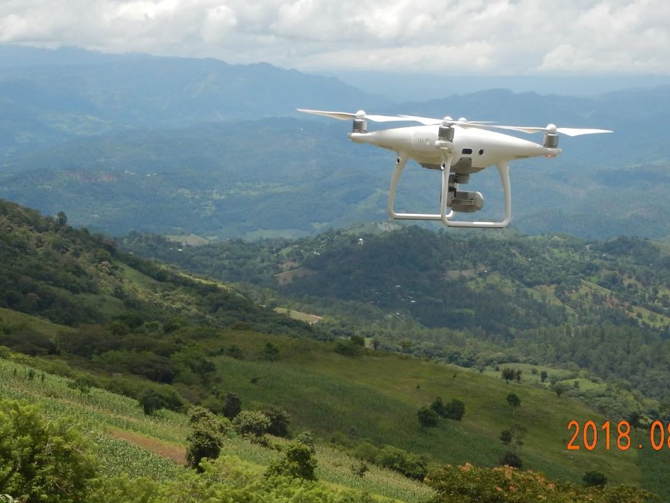
From May 8-12, 2017, the Terra-i team, together with staff from the DGOTA of Peru's Ministry of Environment, carried out the first field validation of vegetative land cover changes detected during Terra-i monitoring for 2016 and 2017, using the technology UAV. This work was carried out under the framework of the project “Sustainable Amazonian Landscapes”. The team carried out over-flights with a Phantom 3 advanced rotor drone and a fixed-wing Ebee drone in seven townships of Yurimaguas. The objective of this work was to recognize the dynamics of land cover and land use changes in the region while at the same time to validate the accuracy of the detections of forest loss being monitored by Terra-i in Yurimaguas.
CIAT and the Terra-i team are pleased to announce the publication of a new study in Paraquaria Natural, the most prestigious journal in Paraguay dedicated to biodiversity and the conservation of nature.


The Terra-i team has worked hard on renovating Terra-i’s website since early this year. A set of new features on the website provides interactive contents and facilitates adaptation to the mobile devices of our users. The fresh website was developed using the latest update of an open-source, Java-based web system, Magnolia CMS 5.4.4. This update was customized to add different categories of interaction such as news, vegetation cover changes, and information, among others.


Globally more than 1 billion people depend on forests for their livelihoods. Forests play a crucial role in climate regulation, ecosystem services provision and regulation, water supply, carbon storage and many other functions that support biodiversity. Currently the global rate of deforestation is substantial, and there is a growing need for timely, spatially explicit data that flag natural vegetation changes due to human activities.


The latest update of Terra-i has been used with the Co$ting Nature ecosystem services assessment tool to understand the impacts of recent forest loss in Colombia on biodiversity and ecosystem services.
The production of geospatial data related to land-use and land cover changes by governments and civil society organizations has vastly increased during the last decade. Going beyond the valuable information (location, rates and absolute values of changes) provided by these datasets, it is important to have a better understanding of the spatial configurations and composition of the detected change areas at multiple spatial resolutions and time periods. Alejandro Coca-Castro’s research is aiming to map types of spatial deforestation patterns in the Amazon rainforest through the integration of landscape fragmentation metrics and data mining techniques. The research will contribute to the understanding of two deforestation datasets (Terra-i and GFC) and is part of his master dissertation at King’s College London. This blog post highlights Alejandro’s research methodology, preliminary findings and challenges.
Ecuador is recognized as one of the biodiverse hotspots on earth, underneath the Amazon rainforest lies the country’s oil reservoir. With the oil companies and cleared routes come settlers, therefore more and more of this diverse rainforest is being cut down. Since the oil concerns entered the Ecuadorian Amazon 45 years ago, they keep exploring and exploiting the area. The Terra-i detections reveal a total habitat loss of 87,525 Ha, 16,943 Ha (19%) is part of protected areas, between January 2004 and February 2015.