
Terra-i deforestation monitoring system going pan-tropical

The first step towards halting tropical deforestation is knowing where it occurs in a timely manner that permits rapid action to address the root causes. Terra-i is the first ever moderate resolution operational deforestation monitoring system outside of Brazil. It provides 16-day updates for land cover change at 250m resolution and updated datasets in Geographical Information System (GIS) formats are made available to a global user community every two months.
Terra-i has been operational for the whole of Latin America (Mexico to Argentina) with a processing hub and distribution system based at CIAT since December 2011 and was officially launched at Rio+20. Thanks to the iCUBE consortium collaboration between the Universiti-Brunei Darussalam and King's College London with CIAT and HEIG-VD, Louis Reymondin now has Terra-i running for Southeast Asia with a processing centre at the UBD-IBM centre.
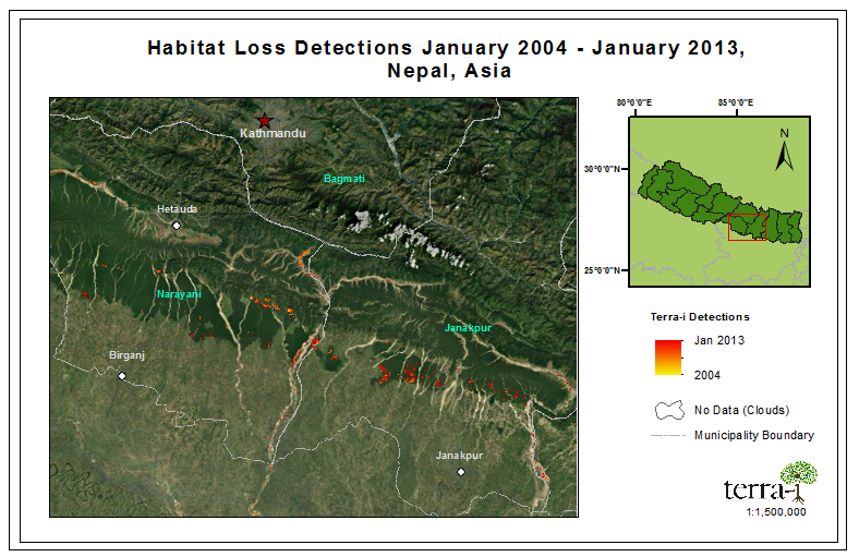
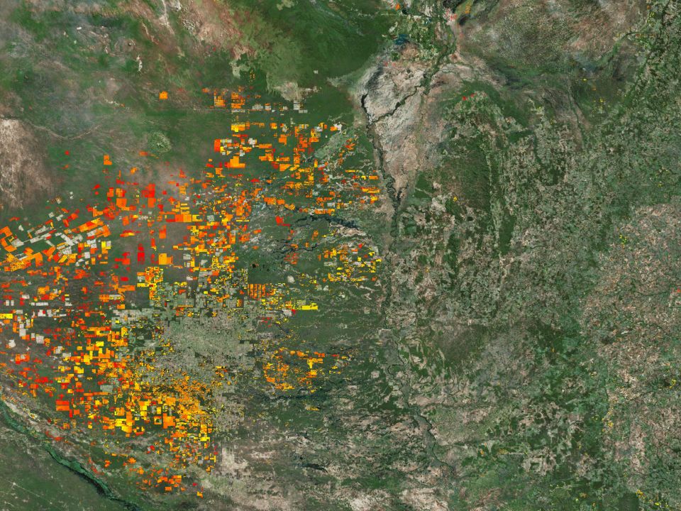
Figure 1. Deforestation in northern India and Nepal 2004-2013, according to Terra-i
We expect to be producing pan-tropical results over the next few months. Initial tests are encouraging, indicating that the system is working reliably in other tropical forest contexts. Figure 1 shows deforestation 2004-2013 for India and Nepal and Figure 2 2004-2012 for Borneo.
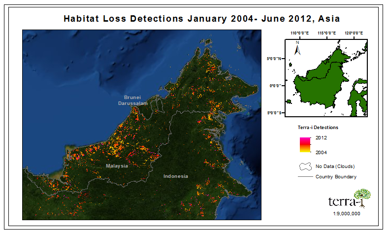
Figure 2. Deforestation in Borneo 2004-2012, according to Terra-i
Terra-i and Policy support
Terra-i produces detailed maps of land cover change as well as time series of areas and rates of change by country, administrative region, protected area and ecosystem. All results can be visualised online at www.terra-i.org, offline on Android tablets and smartphones (see geodata.policysupport.org/terra-i) or downloaded for further analysis in Geographical Information Systems (GIS). Terra-i is linked with the WaterWorld and Co$ting Nature Policy support systems for examining the impacts of recent land cover change on ecosystem services (carbon, water and hazard mitigation) and for generating land use change projections.
The system has been applied to examining the impacts of mining in Peru, large scale deforestation in the Chaco, deforestation in and around protected areas and impacts on water (flooding and water quantity and quality), carbon and biodiversity.
Terra-i is developed by Louis Reymondin who works with Andy Jarvis and his team in the Decision and Policy Analysis unit of the International Center for Tropical Agriculture (CIAT, Colombia) and is PhD student at King's College London, supervised by Mark Mulligan in the Department of Geography. Terra-i is the result of a collaboration between CIAT DAPA, King's College London, the University of Applied Sciences of Western Switzerland (HEIG-VD) (Andres Perez-Uribe) and is funded by The Nature Conservancy.
This article was authored by Mark Mulligan, Louis Reymondin and Andy Jarvis. It was first published on http://www.policysupport.org/home/blog.


IDENTIFICACIÓN DE CAUSAS DE PÉRDIDA DE COBERTURA VEGETAL EN LAS ÁREAS DE INTERVENCIÓN DE LA ACTIVIDAD GOBERNANZA EN ECOSISTEMAS, MEDIOS DE VIDA Y AGUA (USAID/GEMA) EN EL OCCIDENTE DE HONDURAS

MAPEO DE COBERTURAS DE LA TIERRA PARA EL 2017, EN EL OCCIDENTE HONDUREÑO SOBRE ÁREAS DE INTERVENCIÓN DE LA ACTIVIDAD GOBERNANZA EN ECOSISTEMAS, MEDIOS DE VIDA Y AGUA (USAID/GEMA)
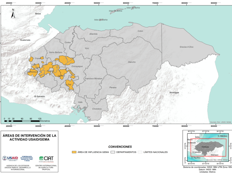

CUANTIFICACIÓN DE LA DEFORESTACIÓN EN LAS ÁREAS DE INTERVENCIÓN DE LA ACTIVIDAD GOBERNANZA EN ECOSISTEMAS, MEDIOS DE VIDA Y AGUA (USAID/GEMA) EN EL OCCIDENTE DE HONDURAS

An international team of scientists*, involving entomologists, conservation biologists, agro-ecologists and geographers, has just revealed how on-farm insect biological control can slow the pace of tropical deforestation and avert biodiversity loss on a macro-scale. The case study concerns biological control of the invasive mealybug Phenacoccus manihoti with the introduced host-specific parasitic wasp Anagyrus lopezi in Southeast Asia. The results of this study have just been published in Communications Biology – Nature.

CIAT and the Terra-i team are pleased to announce the publication of a new study in Paraquaria Natural, the most prestigious journal in Paraguay dedicated to biodiversity and the conservation of nature.
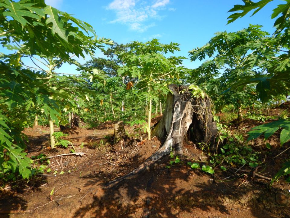

New deforestation hotspots point the finger at my favourite fruit I love Terra-i, but today I hate it. A lot. The system uses satellite images to track deforestation in the Amazon in near-realtime. It’s extremely accurate: if a bunch of trees come down somewhere – no matter how remote – Terra-i picks it up. Cool, right? Not today. CIAT’s Louis Reymondin, the system’s chief architect, dropped the bombshell over coffee: it looks as though hundreds of hectares of rainforest in Peru are being trashed by… papaya.

The production of geospatial data related to land-use and land cover changes by governments and civil society organizations has vastly increased during the last decade. Going beyond the valuable information (location, rates and absolute values of changes) provided by these datasets, it is important to have a better understanding of the spatial configurations and composition of the detected change areas at multiple spatial resolutions and time periods. Alejandro Coca-Castro’s research is aiming to map types of spatial deforestation patterns in the Amazon rainforest through the integration of landscape fragmentation metrics and data mining techniques. The research will contribute to the understanding of two deforestation datasets (Terra-i and GFC) and is part of his master dissertation at King’s College London. This blog post highlights Alejandro’s research methodology, preliminary findings and challenges.

Ecuador is recognized as one of the biodiverse hotspots on earth, underneath the Amazon rainforest lies the country’s oil reservoir. With the oil companies and cleared routes come settlers, therefore more and more of this diverse rainforest is being cut down. Since the oil concerns entered the Ecuadorian Amazon 45 years ago, they keep exploring and exploiting the area. The Terra-i detections reveal a total habitat loss of 87,525 Ha, 16,943 Ha (19%) is part of protected areas, between January 2004 and February 2015.