
Terra-i: No stranger to controversy


Two things tend to happen when people get their hands on a new tool that is fundamentally helpful. First, they discover more uses for it than anyone could have imagined. And second, the more numerous and diverse the uses, the more likely it is that the tool will eventually become associated with conflict and controversy.
Source: science magazine 2014 - McSweeney
A recent application of Terra-I – a decidedly helpful tool for detecting changes in land cover, based on near real-time remote sensing – illustrates both tendencies with unusual clarity. Using data from Terra-i, a group of scientists from several US universities have demonstrated the complex ties between illegal drug trafficking and accelerated deforestation in Honduras, according to an article appearing in the latest issue of the journal Science.
Many previous reports have documented environmental damage caused by the clearing of forest for coca production in South America. But this new study focuses on other links in the drug value chain – revealing how clandestine transportation and money laundering also drive deforestation.
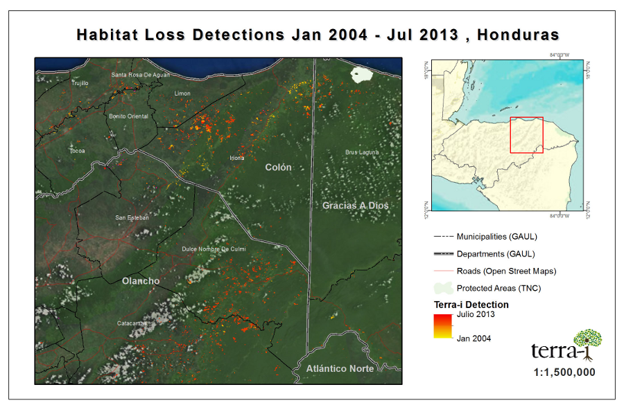
Initially, the raw data downloaded from Terra-i underestimated the extent of the damage. Once the scientists realized this, they contacted the Terra-i team, requesting that the raw data be calibrated to their study area. The CIAT researchers, who “did not know the end use of this data calibration,” the article notes, completed the task in a few months. The adjusted results are those presented in Science – showing “detected deforestation, 2004-2012, in the eastern Honduras narco-trafficking corridor.”
Without the “Terra-I data, we wouldn't have been able to publish these findings so soon,” said Ophelia Wang, a professor in Northern Arizona University’s School of Earth Sciences and Environmental Sustainability. “Also, the Terra-i team was really responsive in helping us with the calibration. This demonstrates how scientists with complementary backgrounds can collaborate to produce important studies that raise public awareness of environmental issues.”
The researchers plan to use Terra-i data for further studies on the links between drug trafficking and deforestation across all of Central America. They also see scope for such work in Peru, were illegal drugs are transported on small planes into Brazil and Bolivia.
Environmental issues, including deforestation, are almost always controversial and often involve conflict. The new findings on “narco-deforestation” reveal a particularly garish thread in the broader pattern of ecological destruction in Latin America.
Against this background, the Terra-i team is constantly on the lookout for new users and applications. So far, they have attracted 1,000 registered users, and in just the last year, 260 organizations from 45 countries have reported using the tool. A recent web conference on Terra-i attracted about 450 people from 27 countries.
“What they all have in common,” said Louis Reymondin, the CIAT researcher who leads the Terra-i team “is a conviction that halting deforestation requires far-reaching changes – certainly in conservation policy but evidently in other policy realms as well, including drug policy. Terra-i users further believe that reliable information tools and friendly assistance in their application are essential for guiding and promoting such changes.”
The image below shows Terra-i results for deforestation in eastern Honduras. www.terra-i.org
Terra-i
Blog post by Nathan Russell, Head of Corporate Communications at CIAT.


The Terra-i team together with CRS El Salvador under the Raices project carried out a virtual workshop through the teams platform to technicians from the Ministry of Environment and Natural Resources, CARITAS, Universidad El Salvador, CENTA, about the Mapping of land cover using remote sensors and open source tools such as GEE, SEPAL and QGIS- Plugin Semi Automatic Classification.


Near real-time vegetation loss detection in Southwestern Ethiopia: calibration, validation, and implementation of the Terra-i system


The Alliance of Bioversity International and the International Center for Tropical Agriculture (CIAT) (the Alliance) conducted a training for local stakeholders on the use of Terra-i as part of the collaboration with the Netherlands Development Organisation – SNV in the Coffee Agroforestry and Forest Enhancement for REDD+ (CAFÉ-REDD) Project.


From May 8-12, 2017, the Terra-i team, together with staff from the DGOTA of Peru's Ministry of Environment, carried out the first field validation of vegetative land cover changes detected during Terra-i monitoring for 2016 and 2017, using the technology UAV. This work was carried out under the framework of the project “Sustainable Amazonian Landscapes”. The team carried out over-flights with a Phantom 3 advanced rotor drone and a fixed-wing Ebee drone in seven townships of Yurimaguas. The objective of this work was to recognize the dynamics of land cover and land use changes in the region while at the same time to validate the accuracy of the detections of forest loss being monitored by Terra-i in Yurimaguas.


The Terra-i team has worked hard on renovating Terra-i’s website since early this year. A set of new features on the website provides interactive contents and facilitates adaptation to the mobile devices of our users. The fresh website was developed using the latest update of an open-source, Java-based web system, Magnolia CMS 5.4.4. This update was customized to add different categories of interaction such as news, vegetation cover changes, and information, among others.


Globally more than 1 billion people depend on forests for their livelihoods. Forests play a crucial role in climate regulation, ecosystem services provision and regulation, water supply, carbon storage and many other functions that support biodiversity. Currently the global rate of deforestation is substantial, and there is a growing need for timely, spatially explicit data that flag natural vegetation changes due to human activities.


The latest update of Terra-i has been used with the Co$ting Nature ecosystem services assessment tool to understand the impacts of recent forest loss in Colombia on biodiversity and ecosystem services.

During the 1st and 12th of June 2015, the Terra-i team, together with the Instituto de Investigaciones de la Amazonía Peruana (IIAP) and the Universidad Nacional Agraria La Molina (VLIR-UNALM), conducted the second field validation of the data produced by the Terra-I system. This time, the study area was the Yurimaguas district, Alto Amazonas province, Loreto region (Peru). We used information on populated places, main roads, rivers and information on land cover changes detected for 2013, 2014 and 2015 to define the 65 sampling points (or Terra-I pixels) for the validation process (Figure 1).