
10 years of habitat loss in the Amazon Caqueta


The Colombian Amazon in Caquetá has lost 141.150 Ha of forest between January 2004 and March 2014, an area similar to London city’s surface. Although tendencies have been decreasing over the past years, areas with forest cover loss increased considerably in 2013.
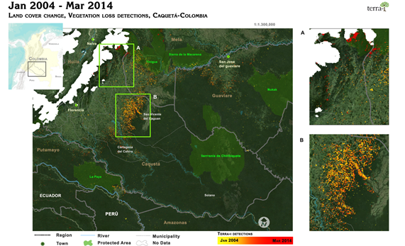
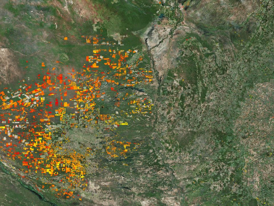
Figure 1. Habitat loss detections in Caquetá, Colombia (January 2004 - March 2014). Detections are mainly located in the municipality of San Vicente del Caguan. The map shows two critical periods for forest cover loss, the first one between 2007 and 2010 in the Amazonia borderlands and the next one in 2011, in the Amazonic piedmont.
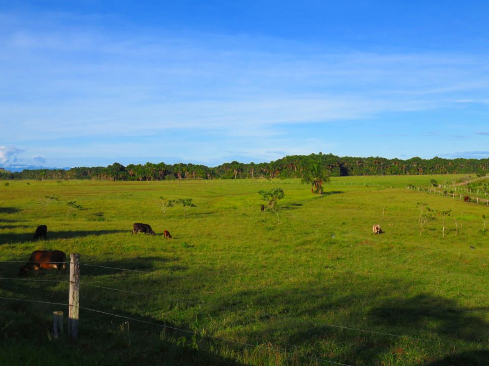
Caqueta is one of Colombia’s departments located in the Amazon, extending over about 9 million Ha. Solano, San Vicente del Caguán and Cartagena del Chaira are the most extensive municipalities of the department with 4.9, 1.8 and 0.88 million Ha respectively.
Even though information about vegetation cover dynamics in the Colombian Amazon is scarce, some authors and organizations have documented these events of land use change dealing with limitations on accurate data. This post aims to discuss tendencies of forest loss in this area based on information of Terra-i detections.
In Colombia, studies of land cover change have focused at the landscape level, while little is known about the patterns and drivers of land cover changes at regional and national levels (Etter et al 2006). For this reason accurate and up-to-date information on vegetation land cover is a necessary tool to adequately design and focus conservation policies and programmes at different levels.
According to Nepstad et al (2013), main deforestation drivers in Colombia are related to agricultural expansion, illegal crop cultivation, internal migration, mining, and infrastructure development. Data shows that deforested areas in the Colombian Amazon reached 5626 km2 between 2000 and 2005. 49.43 % of the land converted (equivalent to 2781 km2) has been associated with establishment of pastures.
Terra-i detections (Figure 1) highlight the spatial patterns of habitat loss in the Colombian Caquetá. These events mainly have occurred on the Amazon borderland between 2004 and 2012, in the municipalities of San Vicente del Caguán and Cartagena del Chaira. However, more recent detections (2013) of deforested areas were located in the north-west of the Caqueta department.
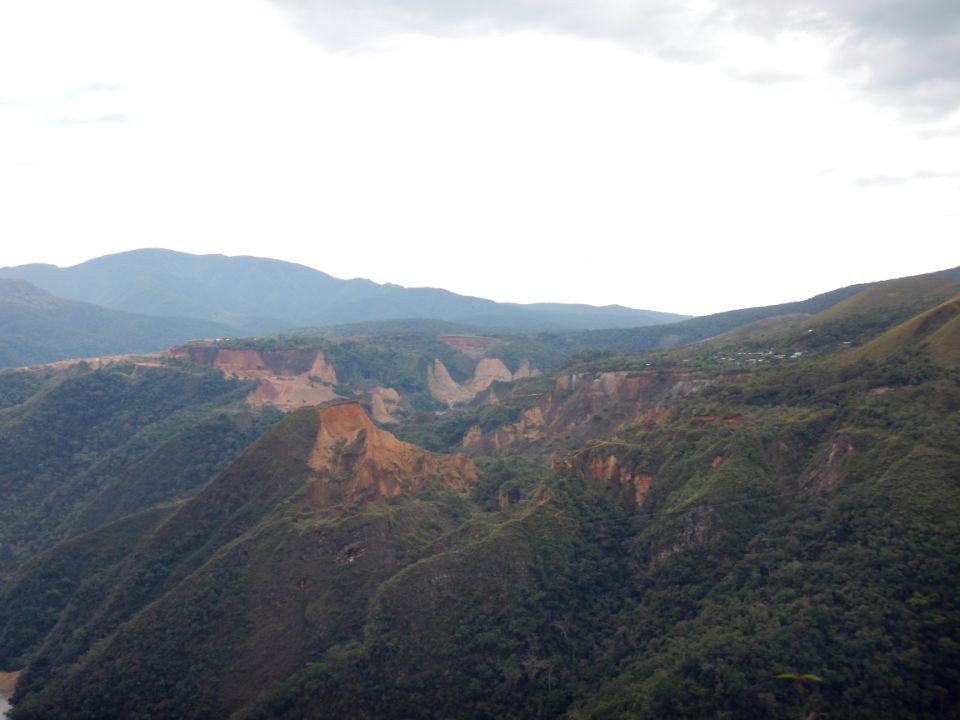
The advancement of the deforestation frontier has been encouraged by logging activities of old and new colonists. In Caquetá, the colonization front has advanced eastwards into the Amazon (Figure 2), where rivers have been key factors to determine the direction of the movements of colonization processes (Etter et al, 2006).
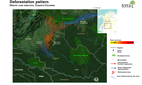
Figure 2. Spatial patterns of habitat loss (January 2004 - March 2014) in the Caquetá department. The expansion of the agricultural frontier and the flow of rivers are key factors that influence the deforestation direction.
Between January 2004 and March 2014, the total accumulated forest loss in the department of Caquetá was 141,150 Ha, corresponding to 2.4% of the department’s total forest area, according to Hansen et al (2000) Land cover dataset. This whole value is also analyzed by municipalities, understanding how each municipality has a different pressure on vegetation cover loss. Figure 3 shows those municipalities with major vegetal cover loss. The highest deforestation rates have been registered in San Vicente del Caguan (69.01% of the total forest loss for this department), where accumulated forest loss reached 96,900 Ha between 2004 and 2014, followed by Cartagena del Chairá with 16.54% of total deforestation loss (23,350 Ha). The other, ten municipalities have registered rather low total accumulated deforestation values (less than 1000 Ha each).
Yearly trends show that peak deforestation events occurred during 2006 and 2011 reaching up to 31,000 Ha in 2008. Figure 3 shows that San Vicente del Caguan is the municipality that shapes the deforestation tendency the department.
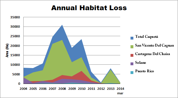
Figure 3. January 2004 to March 2014 Annual Habitat Loss in Caquetá and in the most representative municipalities. San vicente del Caguan is the municipality that shapes the forest loss trends in the department.
The municipalities with largest deforested areas are located on the Amazon border (see Figure 1), which explains the tendency to convert forests into pastures by existing colonists throughout the entire country (Nepstad et al, 2013).
A recent report by the United Nations Integrated Illicit Crops Monitoring System (SIMCI) reveals that high deforestation rates are also linked with the cultivation of coca and associated conflicts. Moreover, illegal mining activities, continuously expanding along the rivers of Caguán and Caquetá, may become important drivers of forest loss in the region.
By analyzing monthly deforestation data, it is evident that more habitat has been lost during the months in December, January and February for each of the studied years. Moreover, comparing these values to IDEAM average rainfall data series, it has been revealed that higher deforestation rates occur in drier seasons of the year (Figure 4). While these observations are useful for future conservation measures, further studies on short term deforestation dynamics and relationships to rainfall periods and other social, institutional, economic and cultural factors are required, in order to improve decision-making.
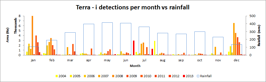
Figure 4. 2004-2013 annual habitat loss trend separated by month compared to rainfall average. December, January and February are the months with highest vegetation cover loss and also the driest months of the year.
CIAT is currently implementing the project ‘Sustainable development options and land-use based alternatives to enhance climate change mitigation and adaptation capacities in the Colombian and Peruvian Amazon, while enhancing ecosystem services and local livelihoods’. This project seeks to assist national environmental authorities and local farmers in Colombia and Peru, to enhance the adaptive and mitigation capacities. Terra-i will make part of the project by monitoring habitat loss in the study areas and the data will be validated in collaboration with the Environment Ministry of Peru (MINAM).
Blog post by Oscar Bautista. Revision of English-language version by Andreea Nowak (CIAT / DAPA visiting researcher).
References
- Etter, A., McAlpine, C., Phinn, S., Pullar, D., and H. Possingham. 2006. Characterizing a tropical deforestation wave: a dynamic spatial analysis of a deforestation hotspot in the Colombian Amazon. Global Change Biology. 1409–1420.
- FAO. 2010. Global forest resources assessment. Main report. Rome, 191 p.
- Hansen, M., Defries, J., Townshed, R., and R. Sohlberg. 2000. Global land cover classification at 1 km spatial resolution using a classification tree approach. Int. J. Remote Sensing. 21. (6, 7). 1331 - 1364.
- Nepstad, D.; Bezerra. T., Tepper, D., McCann, K., Stickler, C., McGrath, D., Barrera, M., Lowery, S., Armijo, E., Higgins, M., Monschke, J., Gomez, R., Velez, S., Tejada, M,. Tejada,M., Killeen, T., Schwalbe, K., and A. Ruedas. 2013. ADDRESSING AGRICULTURAL DRIVERS OF DEFORESTATION IN COLOMBIA: Increasing Land-Based Production While Reducing Deforestation, Forest Degradation, Greenhouse Gas Emissions and Rural Poverty. Commonwealth Office and Department of Energy Climate Change, Forests and Climate Change Programme.


IDENTIFICACIÓN DE CAUSAS DE PÉRDIDA DE COBERTURA VEGETAL EN LAS ÁREAS DE INTERVENCIÓN DE LA ACTIVIDAD GOBERNANZA EN ECOSISTEMAS, MEDIOS DE VIDA Y AGUA (USAID/GEMA) EN EL OCCIDENTE DE HONDURAS

MAPEO DE COBERTURAS DE LA TIERRA PARA EL 2017, EN EL OCCIDENTE HONDUREÑO SOBRE ÁREAS DE INTERVENCIÓN DE LA ACTIVIDAD GOBERNANZA EN ECOSISTEMAS, MEDIOS DE VIDA Y AGUA (USAID/GEMA)

CUANTIFICACIÓN DE LA DEFORESTACIÓN EN LAS ÁREAS DE INTERVENCIÓN DE LA ACTIVIDAD GOBERNANZA EN ECOSISTEMAS, MEDIOS DE VIDA Y AGUA (USAID/GEMA) EN EL OCCIDENTE DE HONDURAS

An international team of scientists*, involving entomologists, conservation biologists, agro-ecologists and geographers, has just revealed how on-farm insect biological control can slow the pace of tropical deforestation and avert biodiversity loss on a macro-scale. The case study concerns biological control of the invasive mealybug Phenacoccus manihoti with the introduced host-specific parasitic wasp Anagyrus lopezi in Southeast Asia. The results of this study have just been published in Communications Biology – Nature.

CIAT and the Terra-i team are pleased to announce the publication of a new study in Paraquaria Natural, the most prestigious journal in Paraguay dedicated to biodiversity and the conservation of nature.

New deforestation hotspots point the finger at my favourite fruit I love Terra-i, but today I hate it. A lot. The system uses satellite images to track deforestation in the Amazon in near-realtime. It’s extremely accurate: if a bunch of trees come down somewhere – no matter how remote – Terra-i picks it up. Cool, right? Not today. CIAT’s Louis Reymondin, the system’s chief architect, dropped the bombshell over coffee: it looks as though hundreds of hectares of rainforest in Peru are being trashed by… papaya.

The production of geospatial data related to land-use and land cover changes by governments and civil society organizations has vastly increased during the last decade. Going beyond the valuable information (location, rates and absolute values of changes) provided by these datasets, it is important to have a better understanding of the spatial configurations and composition of the detected change areas at multiple spatial resolutions and time periods. Alejandro Coca-Castro’s research is aiming to map types of spatial deforestation patterns in the Amazon rainforest through the integration of landscape fragmentation metrics and data mining techniques. The research will contribute to the understanding of two deforestation datasets (Terra-i and GFC) and is part of his master dissertation at King’s College London. This blog post highlights Alejandro’s research methodology, preliminary findings and challenges.

Ecuador is recognized as one of the biodiverse hotspots on earth, underneath the Amazon rainforest lies the country’s oil reservoir. With the oil companies and cleared routes come settlers, therefore more and more of this diverse rainforest is being cut down. Since the oil concerns entered the Ecuadorian Amazon 45 years ago, they keep exploring and exploiting the area. The Terra-i detections reveal a total habitat loss of 87,525 Ha, 16,943 Ha (19%) is part of protected areas, between January 2004 and February 2015.