
The third update of TERRA-i Peru - What is it all about?


Since TERRA-i Peru was officially launched in April 2014, it has been applied as an early warning system for land cover and land-use change in Peru. The collaborative framework agreement signed between the International Center of Tropical Agriculture (CIAT) and the Peruvian Ministry of Environment (MINAM), implemented the new early warning system successfully, producing as a result the third monthly update. Outcomes and dissemination by the MINAM representative team in Peru (The General Directorate for Territorial Planning - DGOT) and the Terra-i/CIAT team have been relevant for the continuity of this initiative which has the following objectives for the remaining semester of 2014: 1) to reduce the time of detection and update of changes, 2) to validate and quantify the accuracy of the detections; and 3) to ensure the use of the tool, in decision-making in land-conversion dynamics.
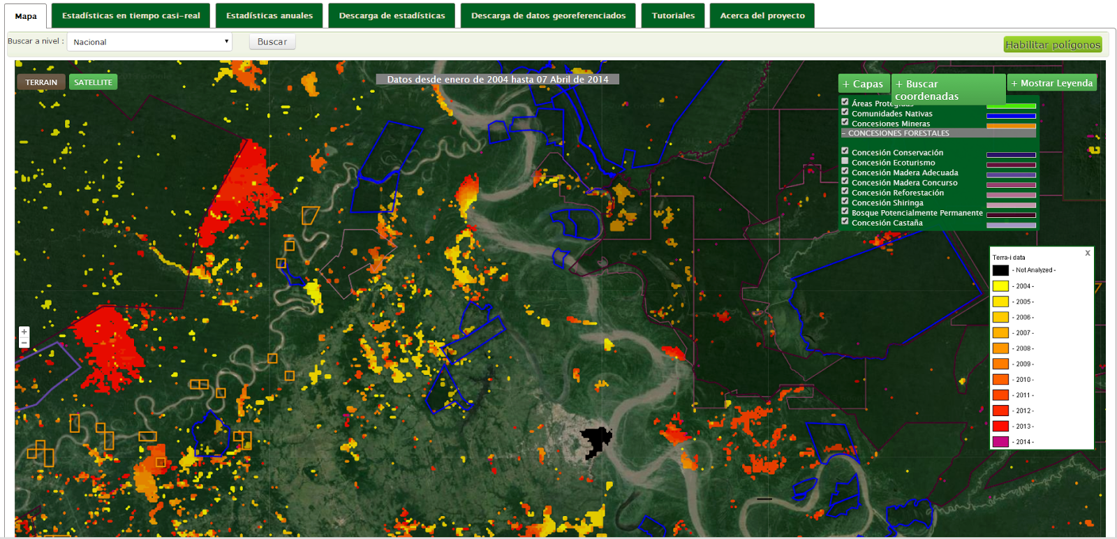
Figure 1. TERRA-i Peru, a user-friendly online platform working with Google APIs, includes multiple options to visualize and extract spatial and tabular data of vegetation changes from the Terra-i system for different thematic layers (administrative levels, mining concession, conservation areas, among others) recognized by official institutions in Peru.
As part of the framework agreement signed on 10 March this year by the Ministry of Environment (MINAM) and the International Centre for Tropical Agriculture (CIAT), a mutual commitment between these institutions has been established to provide stakeholders with a constantly updated status of the land cover and land-use dynamics based on the monitoring of the TERRA-i Peru tool.
In addition to the benefits of this online platform, which allows users to extract vegetation change data, it is expected to adapt this system to the Peruvian context to monitor almost all types of the vegetation cover. Thus, until now, the Terra-i/CIAT team has focused on improving the visualization of the thematic layers and to develop a tutorial section in order to enable users to handle the information given by the tool adequately. On a short term perspective, it is expected to improve the delivery time of the change detections (currently released two months after the disturbance occurred) and to implement a consolidate validation strategy, supported by images with better spatial resolution and collected field data.
The role of the DGOT/MINAM team has also been key for supporting and transferring knowledge about how to use and interpret the TERRA-i Peru data to multiple official agencies. Specifically, the following outcomes demonstrate their advances:
1. Incorporation of Peru TERRA-i tool in the management of the Peruvian protected areas network: this include activities that are being implemented by them and the National Service of Protected Natural Areas (SERNANP) to use tools such as the TERRA-i Peru for the protected areas network management. In this way, the tool allows to identify the conservation areas with the greatest dynamics of vegetation change and thus deserve special treatment and control actions by the park rangers. In addition, a set of training workshops at macro regional level to managers and ranger are being scheduled from August 2014 onwards.
2. Reports of land cover change at country level to the Peruvian Ministry of Economy and Finance (MEF): this is an action that has been implemented since January 2014 and is aimed to deliver monthly reports to support strategic processes of decision-making. It is planned to develop an online reporting system which offers easy access to MEF personal.
3. Develop an integrated early detection system for environmental monitoring for the Governmental Budget Program 136 "Prevention and environmental remediation of contaminated and degraded land by illegal and informal (small-scale and artisanal) mining areas". In May 2014 , MINAM has approved this budget program delegating the activity 1.2 to DGOT. This activity considers to implement the TERRA-i Peru system to achieve the program aim. As a consequence, it is expected to deliver sixteen-day to monthly reports and to supplement them with data from an unmanned aerial vehicle (UAV). Madre de Dios, the most affected area by informal mining, is expected to be one of the first working areas.
4. TERRA-i Peru as part of "TERRITORIAL INFORMATION AND MONITORING" module in the GEOSERVER platform: currently with an incoming version 2.0 of the GEOSERVER, this new highlighted section would allow users to have free access to resources such as: the Early Warning System (TERRA-i Peru); Deforestation and Forest Degradation (CLASlite); and Coverage and Land-use (CORINE).
The above outcomes together with the methodological flexibility of the Terra-i approach, will allow to facilitate the integration and coordination with other initiatives from national and international organizations working in this country.
Finally, it is important to highlight that common efforts between GEOSERVER platform and Terra-i from MINAM and CIAT, respectively, have been recognized by regional institutions such as the Pan-American Institute of Geography and History (IPGH) and the Development Bank of Latin America (CAF). In this way, their impact and innovation was awarded by those institutions through the GeoSUR program, which is promoting the development of free access geographic services useful to find, view and analyze spatial information in the region.
Blog post by the DGOT/MINAM and Terra-i/CIAT team. Revision of English-language version by Nora Guerten (CIAT / DAPA visiting researcher).


The Terra-i team together with CRS El Salvador under the Raices project carried out a virtual workshop through the teams platform to technicians from the Ministry of Environment and Natural Resources, CARITAS, Universidad El Salvador, CENTA, about the Mapping of land cover using remote sensors and open source tools such as GEE, SEPAL and QGIS- Plugin Semi Automatic Classification.


Near real-time vegetation loss detection in Southwestern Ethiopia: calibration, validation, and implementation of the Terra-i system


The Alliance of Bioversity International and the International Center for Tropical Agriculture (CIAT) (the Alliance) conducted a training for local stakeholders on the use of Terra-i as part of the collaboration with the Netherlands Development Organisation – SNV in the Coffee Agroforestry and Forest Enhancement for REDD+ (CAFÉ-REDD) Project.


From May 8-12, 2017, the Terra-i team, together with staff from the DGOTA of Peru's Ministry of Environment, carried out the first field validation of vegetative land cover changes detected during Terra-i monitoring for 2016 and 2017, using the technology UAV. This work was carried out under the framework of the project “Sustainable Amazonian Landscapes”. The team carried out over-flights with a Phantom 3 advanced rotor drone and a fixed-wing Ebee drone in seven townships of Yurimaguas. The objective of this work was to recognize the dynamics of land cover and land use changes in the region while at the same time to validate the accuracy of the detections of forest loss being monitored by Terra-i in Yurimaguas.


The Terra-i team has worked hard on renovating Terra-i’s website since early this year. A set of new features on the website provides interactive contents and facilitates adaptation to the mobile devices of our users. The fresh website was developed using the latest update of an open-source, Java-based web system, Magnolia CMS 5.4.4. This update was customized to add different categories of interaction such as news, vegetation cover changes, and information, among others.


Globally more than 1 billion people depend on forests for their livelihoods. Forests play a crucial role in climate regulation, ecosystem services provision and regulation, water supply, carbon storage and many other functions that support biodiversity. Currently the global rate of deforestation is substantial, and there is a growing need for timely, spatially explicit data that flag natural vegetation changes due to human activities.


The latest update of Terra-i has been used with the Co$ting Nature ecosystem services assessment tool to understand the impacts of recent forest loss in Colombia on biodiversity and ecosystem services.

During the 1st and 12th of June 2015, the Terra-i team, together with the Instituto de Investigaciones de la Amazonía Peruana (IIAP) and the Universidad Nacional Agraria La Molina (VLIR-UNALM), conducted the second field validation of the data produced by the Terra-I system. This time, the study area was the Yurimaguas district, Alto Amazonas province, Loreto region (Peru). We used information on populated places, main roads, rivers and information on land cover changes detected for 2013, 2014 and 2015 to define the 65 sampling points (or Terra-I pixels) for the validation process (Figure 1).