
The benefits of MODIS


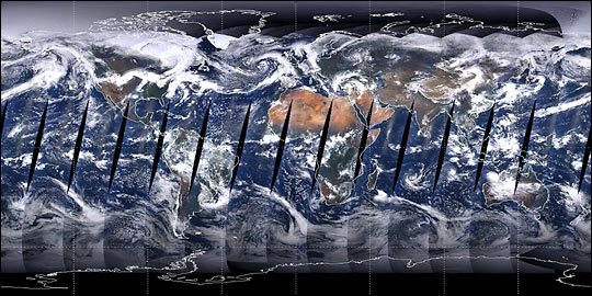
The MODIS (Moderate Resolution Imaging Spectroradiometer) sensor is on board the Terra and Aqua satellites that are part of the EOS (Earth Observing System) of NASA. They provide images of the entire planet Earth every 1 to 2 days with high radiometric sensitivity, 12 bit, 36 bands of the electromagnetic spectrum of wavelengths ranging from 0.4 to 14.4 microns. Two of these bands have a nominal spatial resolution (at nadir) of 250 meters, five of 500 meters, and the 29 remaining bands of 1 kilometer.
In addition to multispectral imagery, MODIS has 44 standard data products enabled us to improve our understanding of global dynamics and processes occurring in the earth, oceans, and atmosphere, playing a major role in the development of predictive models of global climate change, monitoring of deforestation, forest fires, droughts and floods among others.
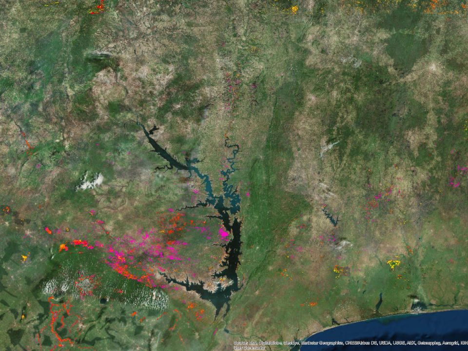
DAPA has more than 500 grids in Latin America for the MODIS vegetation indices (MOD13) EVI (enhanced vegetation index) and NDVI (Normalized Difference Vegetation Index) every 16 days from February 2000 until today. This data is used in the development of major research projects in the program, including "Terra-i: Monitor habitat changes in Latin America using neural networks and MODIS satellite data."
Between 14 and 19 August in the First Regional Workshop on Monitoring Forest Service organized by GEO and the United States Geological Survey (USGS) in Lima, Peru, whose main objective is to provide basic knowledge in remote sensing, Karolina Argote on behalf of DAPA, will contribute to strengthening the technical capabilities of scientific and academic community working in forest monitoring, participating in a series of talks at this event.


The Terra-i team together with CRS El Salvador under the Raices project carried out a virtual workshop through the teams platform to technicians from the Ministry of Environment and Natural Resources, CARITAS, Universidad El Salvador, CENTA, about the Mapping of land cover using remote sensors and open source tools such as GEE, SEPAL and QGIS- Plugin Semi Automatic Classification.


Near real-time vegetation loss detection in Southwestern Ethiopia: calibration, validation, and implementation of the Terra-i system


The Alliance of Bioversity International and the International Center for Tropical Agriculture (CIAT) (the Alliance) conducted a training for local stakeholders on the use of Terra-i as part of the collaboration with the Netherlands Development Organisation – SNV in the Coffee Agroforestry and Forest Enhancement for REDD+ (CAFÉ-REDD) Project.


From May 8-12, 2017, the Terra-i team, together with staff from the DGOTA of Peru's Ministry of Environment, carried out the first field validation of vegetative land cover changes detected during Terra-i monitoring for 2016 and 2017, using the technology UAV. This work was carried out under the framework of the project “Sustainable Amazonian Landscapes”. The team carried out over-flights with a Phantom 3 advanced rotor drone and a fixed-wing Ebee drone in seven townships of Yurimaguas. The objective of this work was to recognize the dynamics of land cover and land use changes in the region while at the same time to validate the accuracy of the detections of forest loss being monitored by Terra-i in Yurimaguas.


The Terra-i team has worked hard on renovating Terra-i’s website since early this year. A set of new features on the website provides interactive contents and facilitates adaptation to the mobile devices of our users. The fresh website was developed using the latest update of an open-source, Java-based web system, Magnolia CMS 5.4.4. This update was customized to add different categories of interaction such as news, vegetation cover changes, and information, among others.


Globally more than 1 billion people depend on forests for their livelihoods. Forests play a crucial role in climate regulation, ecosystem services provision and regulation, water supply, carbon storage and many other functions that support biodiversity. Currently the global rate of deforestation is substantial, and there is a growing need for timely, spatially explicit data that flag natural vegetation changes due to human activities.


The latest update of Terra-i has been used with the Co$ting Nature ecosystem services assessment tool to understand the impacts of recent forest loss in Colombia on biodiversity and ecosystem services.

During the 1st and 12th of June 2015, the Terra-i team, together with the Instituto de Investigaciones de la Amazonía Peruana (IIAP) and the Universidad Nacional Agraria La Molina (VLIR-UNALM), conducted the second field validation of the data produced by the Terra-I system. This time, the study area was the Yurimaguas district, Alto Amazonas province, Loreto region (Peru). We used information on populated places, main roads, rivers and information on land cover changes detected for 2013, 2014 and 2015 to define the 65 sampling points (or Terra-I pixels) for the validation process (Figure 1).