
Terra-i wins the 2013 GeoSUR Award


Terra-i’s team of researchers, led by Louis Reymondin, has a new reason to celebrate. On Friday November 22nd in Montevideo, Uruguay, they received the 2013 GeoSUR Award during the Sixth Meeting of the Geospatial Network of Latin America and the Caribbean (GeoSUR). About 50 attendants were present during the awards ceremony, including managers and representatives of the official cartographic information centers of 21 Latin American countries.
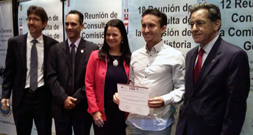
From left to right, Eric van Praag, GeoSUR regional coordinator; Rigoberto Magaña, IPGH president; Claudia Ulloa, IPGH technical cooperation; Alejandro Coca, Terra-i team member; and Santiago Borrero, IPGH general secretary
GeoSUR is a network of institutions coordinated by the Development Bank of Latin America and the Pan American Institute of Geography and History (IPGH). It has recognized Terra-i for its contribution to the development of multi-purpose geospatial management for various countries of in Latin America.
Terra-i, a system for monitoring near real time natural habitat loss in Latin America, detects changes in land cover resulting from human activities using satellite imagery captured every 16 days. The data outputs of the tool are then reported on an interactive website-free and open access – that allows the user to investigate and monitor changes in land use throughout Latin America and the Caribbean. Currently the team is working on expanding Terra-i’s coverage to the whole of the tropics.
Alejandro Coca, researcher at CIAT, represented the Terra-i team during the awards ceremony. The certificate of recognition and an award of USD 2,000 were presented to Alejandro by the regional coordinator of GeoSUR and the president, technical co-operator and general secretary of the IPGH.
In his brief acceptance speech, Alejandro took the opportunity to thank donors such as the Nature Conservancy for the support they have provided to the Terra-i initiative. He also acknowledged the constant collaboration of the University of Applied Sciences and Arts of Western Switzerland and King's College London, the untiring effort and dedication of professionals, student interns and postgraduate students at the Decision and Policy Analysis research area at CIAT and the active interest shown by the general community of users. All of these players are key to making Terra-i a useful tool for better decision-making on a crucial issues such as deforestation and loss of natural habitats in Latin America.
Congratulations to all Terra-i team members and supporters!
This post was originally published in Spanish on the CIAT news blog.
Blog by Andrea Carvajal, CIAT Communications


The Terra-i team together with CRS El Salvador under the Raices project carried out a virtual workshop through the teams platform to technicians from the Ministry of Environment and Natural Resources, CARITAS, Universidad El Salvador, CENTA, about the Mapping of land cover using remote sensors and open source tools such as GEE, SEPAL and QGIS- Plugin Semi Automatic Classification.


Near real-time vegetation loss detection in Southwestern Ethiopia: calibration, validation, and implementation of the Terra-i system


The Alliance of Bioversity International and the International Center for Tropical Agriculture (CIAT) (the Alliance) conducted a training for local stakeholders on the use of Terra-i as part of the collaboration with the Netherlands Development Organisation – SNV in the Coffee Agroforestry and Forest Enhancement for REDD+ (CAFÉ-REDD) Project.


From May 8-12, 2017, the Terra-i team, together with staff from the DGOTA of Peru's Ministry of Environment, carried out the first field validation of vegetative land cover changes detected during Terra-i monitoring for 2016 and 2017, using the technology UAV. This work was carried out under the framework of the project “Sustainable Amazonian Landscapes”. The team carried out over-flights with a Phantom 3 advanced rotor drone and a fixed-wing Ebee drone in seven townships of Yurimaguas. The objective of this work was to recognize the dynamics of land cover and land use changes in the region while at the same time to validate the accuracy of the detections of forest loss being monitored by Terra-i in Yurimaguas.


The Terra-i team has worked hard on renovating Terra-i’s website since early this year. A set of new features on the website provides interactive contents and facilitates adaptation to the mobile devices of our users. The fresh website was developed using the latest update of an open-source, Java-based web system, Magnolia CMS 5.4.4. This update was customized to add different categories of interaction such as news, vegetation cover changes, and information, among others.


Globally more than 1 billion people depend on forests for their livelihoods. Forests play a crucial role in climate regulation, ecosystem services provision and regulation, water supply, carbon storage and many other functions that support biodiversity. Currently the global rate of deforestation is substantial, and there is a growing need for timely, spatially explicit data that flag natural vegetation changes due to human activities.


The latest update of Terra-i has been used with the Co$ting Nature ecosystem services assessment tool to understand the impacts of recent forest loss in Colombia on biodiversity and ecosystem services.

During the 1st and 12th of June 2015, the Terra-i team, together with the Instituto de Investigaciones de la Amazonía Peruana (IIAP) and the Universidad Nacional Agraria La Molina (VLIR-UNALM), conducted the second field validation of the data produced by the Terra-I system. This time, the study area was the Yurimaguas district, Alto Amazonas province, Loreto region (Peru). We used information on populated places, main roads, rivers and information on land cover changes detected for 2013, 2014 and 2015 to define the 65 sampling points (or Terra-I pixels) for the validation process (Figure 1).