

Terra-i highlighted in the Annual Report 2012 of CIAT


Recently, the research results of the Terra-i team has been selected to be published in the Annual Report 2012 of CIAT. Prior to this publication, Neil Palmer, communications officer and CIAT photographer, wrote a post titled "Eye in the sky: Terra-i keeps track of deforestation” shared in the section below. Additionally, a Terra-i updated (under review) up to October 2012 will be delivered soon on the website. Finally, a web tool will allow to download Terra-i data in user friendly formats such as tables and reports.
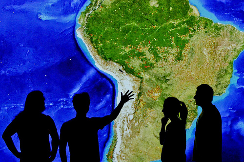
Pic by Neil Palmer (CIAT).
The recent launch of Terra-i, a near real-time deforestation monitoring system for Latin America, brings the hotspots of forest loss into sharp focus.
Based on satellite information from NASA, Terra-i can zoom-in on the region’s forests to a resolution of 250m x 250m. It’s smart enough to distinguish between natural losses and those caused by human activity – and can also monitor habitat change in non-forested areas, such as savannahs and deserts. Anyone can log in and watch what’s happening – from anywhere in the world – and with images updated every 16 days, little escapes the all-seeing Terra-i.
Developed by CIAT, The Nature Conservancy, King’s College London and the University of Applied Sciences and Arts Western Switzerland, Terra-i is aimed at helping governments and decision makers in Latin America formulate new policies on forest and habitat protection – and test the effectiveness of existing ones. With agriculture a major driver of deforestation in the region, Terra-i can also help identify high-priority areas for the implementation of REDD+ schemes, which aim to reduce carbon dioxide emissions from deforestation and forest degradation by engaging local communities to protect the forests.
While Brazil has had its own hi-tech deforestation monitoring system in place since 2008, Terra-i is the first to cover Latin America as a whole, from Mexico to Argentina.
Already it has enabled scientists to focus on areas that often slip under the deforestation radar, for example, the Gran Chaco – a highland, dry forest spreading across Paraguay, Argentina, Bolivia and parts of southern Brazil. The second-most densely forested area in Latin America after the Amazon, it’s a biodiversity hotspot and a living museum of pre-human plants, but its plight has been overshadowed by international focus on its neighbour, the Amazon itself.
Launch in mid-2012, Terra-i revealed that around 1 million hectares of forest had been lost in the Gran Chaco between 2004-2010, driven by the expansion of soy plantations, together with the displacement of cattle ranchers into the region by industrial agriculture at the perimeter.
“The rates of deforestation in The Chaco were a huge surprise to us,” explained Terra-i team leader and CIAT researcher Louis Reymondin. ”There’s so much focus on the Amazon – and rightly so – but what we witnessed in The Chaco was much more severe than anywhere in the Amazon.
“If governments are going to develop policies to tackle these kinds of threats to forests, biodiversity, and environmental services, they have to understand the dynamics of each region, and what the drivers of deforestation and habitat change are. Terra-i can help them do this accurately.”
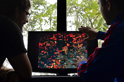
Members of the Terra-i team discuss the Terra-i deforestation monitoring system, which can zoom-in on Latin America's forest to track deforestation in near real-time.
Pic by Neil Palmer (CIAT)
Open source and free-of-charge, Terra-i means lower-income countries in Latin America now have the chance to monitor deforestation themselves. At the end of 2012 the Terra-i team trained technicians from the Bolivian government on how to use the system.
“Until now, satellite-based deforestation monitoring has been prohibitively expensive for many developing countries – and many of these countries are the most vulnerable,” continued Reymondin. “With Terra-i, we’re aiming to put the technology in the hands of the people who need it most.”
In 2013 the team hopes to rally support to develop the system for other parts of the world, helping monitor deforestation high-risk areas in Borneo and the Democratic Republic of Congo.
Originally post in: http://www.ciatnews.cgiar.org/2013/02/14/keeping-an-i-on-deforestation/


The Terra-i team together with CRS El Salvador under the Raices project carried out a virtual workshop through the teams platform to technicians from the Ministry of Environment and Natural Resources, CARITAS, Universidad El Salvador, CENTA, about the Mapping of land cover using remote sensors and open source tools such as GEE, SEPAL and QGIS- Plugin Semi Automatic Classification.


Near real-time vegetation loss detection in Southwestern Ethiopia: calibration, validation, and implementation of the Terra-i system


The Alliance of Bioversity International and the International Center for Tropical Agriculture (CIAT) (the Alliance) conducted a training for local stakeholders on the use of Terra-i as part of the collaboration with the Netherlands Development Organisation – SNV in the Coffee Agroforestry and Forest Enhancement for REDD+ (CAFÉ-REDD) Project.


From May 8-12, 2017, the Terra-i team, together with staff from the DGOTA of Peru's Ministry of Environment, carried out the first field validation of vegetative land cover changes detected during Terra-i monitoring for 2016 and 2017, using the technology UAV. This work was carried out under the framework of the project “Sustainable Amazonian Landscapes”. The team carried out over-flights with a Phantom 3 advanced rotor drone and a fixed-wing Ebee drone in seven townships of Yurimaguas. The objective of this work was to recognize the dynamics of land cover and land use changes in the region while at the same time to validate the accuracy of the detections of forest loss being monitored by Terra-i in Yurimaguas.


The Terra-i team has worked hard on renovating Terra-i’s website since early this year. A set of new features on the website provides interactive contents and facilitates adaptation to the mobile devices of our users. The fresh website was developed using the latest update of an open-source, Java-based web system, Magnolia CMS 5.4.4. This update was customized to add different categories of interaction such as news, vegetation cover changes, and information, among others.


Globally more than 1 billion people depend on forests for their livelihoods. Forests play a crucial role in climate regulation, ecosystem services provision and regulation, water supply, carbon storage and many other functions that support biodiversity. Currently the global rate of deforestation is substantial, and there is a growing need for timely, spatially explicit data that flag natural vegetation changes due to human activities.


The latest update of Terra-i has been used with the Co$ting Nature ecosystem services assessment tool to understand the impacts of recent forest loss in Colombia on biodiversity and ecosystem services.

During the 1st and 12th of June 2015, the Terra-i team, together with the Instituto de Investigaciones de la Amazonía Peruana (IIAP) and the Universidad Nacional Agraria La Molina (VLIR-UNALM), conducted the second field validation of the data produced by the Terra-I system. This time, the study area was the Yurimaguas district, Alto Amazonas province, Loreto region (Peru). We used information on populated places, main roads, rivers and information on land cover changes detected for 2013, 2014 and 2015 to define the 65 sampling points (or Terra-I pixels) for the validation process (Figure 1).