
Terra-i: Eyes on the users


Today, Terra-i has an eye on its users rather than the habitat of Latin America. As the year draws to a close, it’s time to take a look back and characterise the geography of current Terra-i users, their areas of interest and the types of uses to which the tool is being put using statistics from November 2012 to November 2013.
The typical Terra-i user
Terra-i detects land cover changes resulting from human activities in near real time, producing updates every 16 days. It currently runs for the whole of Latin America and is being expanded over the next year to cover the entire tropics. Terra-i is a collaboration between the International Center for Tropical Agriculture (CIAT - DAPA, Colombia), The Nature Conservancy (TNC), the School of Business and Engineering (HEIG-VD, Switzerland) and King’s College London (KCL, UK). It has grown considerably since its launch in early 2012 , reaching a much wider group of users through a simple web-based interface aimed at supporting decision making and policy formulation.
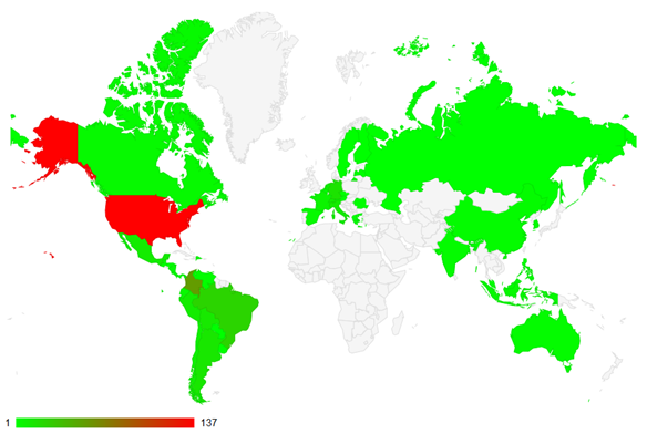
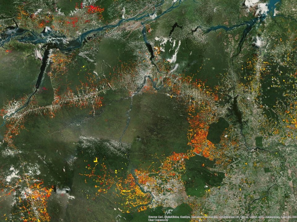
Figure 1: Number of registered users per country
The system has about 1,000 registered users. In the last year Terra-i has been used by 260 organisations from 45 countries. Users are distributed geographically as shown in Figure 1, with a particularly strong presence in the USA, Latin America and Europe. The number of organisations using the systems is greatest in North America and South America. Relatively few organisations, with low use per organisation, based in Europe and Asia are currently using the system.
Areas of interest
A snapshot of the areas in which the tool had been applied by users is given in Figure 2. Terra-i statistical data have been downloaded about 4,200 times, largely in Brazil, Colombia, Peru and Paraguay in South America and in Mexico and Honduras in Central America.
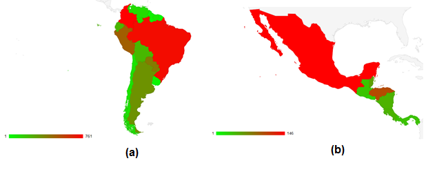
Figure 2 Number of Terra-i queries per country in (a) South America and (b) Central America.
When analysed at a local scale, one can see that the hotspots of queries in South America, as shown in Figure 3, are located in Madre de Dios and Ucayali in Peru, in Caquetá and Antioquia in Colombia and in Alto Paraguay. Furthermore, one can see that most of the queries are clustered in the non-Brazilian Amazon and the Gran Chaco.
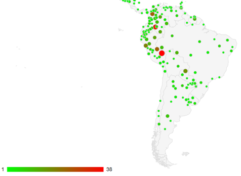
Figure 3: Number of Terra-i queries per locale in South America
In Central America, users were most interested in knowing the trends of habitat loss in Gracias a Dios, Yoro and Lempira in Honduras, Orange Walk in Belize and Durango in Mexico as shown in Figure 4.
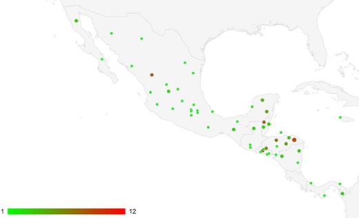
Figure 4: Number of Terra-i queries per locale in Central America
Furthermore, the ecosystems that have the most been consulted by users are the Dry Chaco in Paraguay and Argentina, the Cerrado and Bahia coastal forests in Brazil and the Caquetá Moist forests and Llanos in Colombia. The protected areas that summed the most requests are Jamari and Itacaiunas located in Brazil, Yasuní in Ecuador, Defensores del Chaco in Paraguay and El Tuparro in Colombia. Finally, the most-searched indigenous areas in 2013 were Xikrin do Rio Catete, Parakanã and Córrego João Pereira in Brazil together with Agua Negra and Rio Pangui in Colombia.
Example Uses
Several documented examples of the uses that people outside of the Terra-i team have made of the tool include TNC’s assessment of the status of protected areas in Latin America, GreenWood’s demonstration of how a community forest management area is disappearing due to illegal encroachment in Copen, Honduras and Mongabay’s work showing that deforestation surged after Ecuador killed its Amazon protection plan.
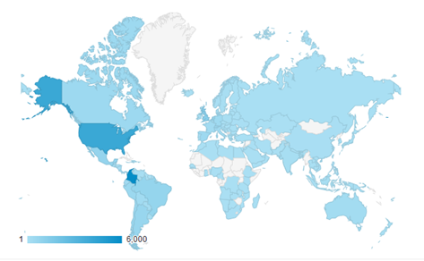
Figure 5: Registered visits on www.terra-i.org
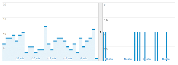
Finally, as shown in Figure 5, Terra-i’s website registered about 21,244 visits that were mainly located in Colombia and the US. All of these users are key to making Terra-i an integral tool for better decision making on crucial issues such as deforestation and loss of natural habitats in Latin America and, soon, the rest of the tropics.


The Terra-i team together with CRS El Salvador under the Raices project carried out a virtual workshop through the teams platform to technicians from the Ministry of Environment and Natural Resources, CARITAS, Universidad El Salvador, CENTA, about the Mapping of land cover using remote sensors and open source tools such as GEE, SEPAL and QGIS- Plugin Semi Automatic Classification.


Near real-time vegetation loss detection in Southwestern Ethiopia: calibration, validation, and implementation of the Terra-i system


The Alliance of Bioversity International and the International Center for Tropical Agriculture (CIAT) (the Alliance) conducted a training for local stakeholders on the use of Terra-i as part of the collaboration with the Netherlands Development Organisation – SNV in the Coffee Agroforestry and Forest Enhancement for REDD+ (CAFÉ-REDD) Project.


From May 8-12, 2017, the Terra-i team, together with staff from the DGOTA of Peru's Ministry of Environment, carried out the first field validation of vegetative land cover changes detected during Terra-i monitoring for 2016 and 2017, using the technology UAV. This work was carried out under the framework of the project “Sustainable Amazonian Landscapes”. The team carried out over-flights with a Phantom 3 advanced rotor drone and a fixed-wing Ebee drone in seven townships of Yurimaguas. The objective of this work was to recognize the dynamics of land cover and land use changes in the region while at the same time to validate the accuracy of the detections of forest loss being monitored by Terra-i in Yurimaguas.


The Terra-i team has worked hard on renovating Terra-i’s website since early this year. A set of new features on the website provides interactive contents and facilitates adaptation to the mobile devices of our users. The fresh website was developed using the latest update of an open-source, Java-based web system, Magnolia CMS 5.4.4. This update was customized to add different categories of interaction such as news, vegetation cover changes, and information, among others.


Globally more than 1 billion people depend on forests for their livelihoods. Forests play a crucial role in climate regulation, ecosystem services provision and regulation, water supply, carbon storage and many other functions that support biodiversity. Currently the global rate of deforestation is substantial, and there is a growing need for timely, spatially explicit data that flag natural vegetation changes due to human activities.


The latest update of Terra-i has been used with the Co$ting Nature ecosystem services assessment tool to understand the impacts of recent forest loss in Colombia on biodiversity and ecosystem services.

During the 1st and 12th of June 2015, the Terra-i team, together with the Instituto de Investigaciones de la Amazonía Peruana (IIAP) and the Universidad Nacional Agraria La Molina (VLIR-UNALM), conducted the second field validation of the data produced by the Terra-I system. This time, the study area was the Yurimaguas district, Alto Amazonas province, Loreto region (Peru). We used information on populated places, main roads, rivers and information on land cover changes detected for 2013, 2014 and 2015 to define the 65 sampling points (or Terra-I pixels) for the validation process (Figure 1).