
Recent scientific publication about Land degradation inside protected areas based on Terra-i data


A team of scientist from The Nature Conservancy (TNC) and the International Centre for Tropical Agriculture (CIAT) have published an article in the open journal Diversity titled “Land and Forest Degradation inside Protected Areas in Latin America”
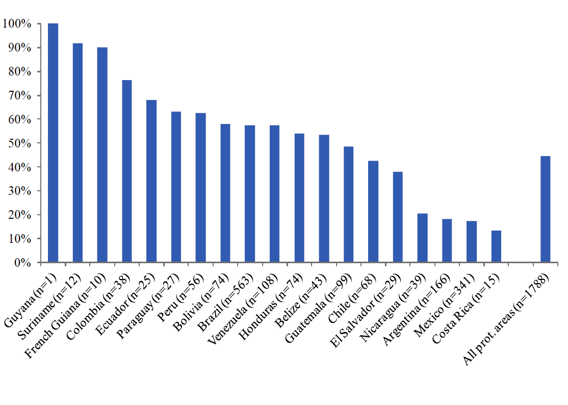
Figure 1. 2004-2009 Proportion of protected areas with land and forest degradation by country
Using six years of remote sensing data (Terra-i outputs), the team estimated land and forest degradation inside 1788 protected areas across 19 countries in Latin America (Figure 1). From 2004–2009, the rate of land and forest degradation increased by 250% inside the protected areas, and the land and forest degradation totalled 1,097,618 hectares. Of the protected areas in the analysed dataset, 45% had land and forest degradation. There were relatively large variations by major habitat type, with flooded grasslands/savannas and moist broadleaf forest protected areas having the highest rates of degradation.
No association was found between a country’s rate of land and forest degradation inside protected areas and Gross Domestic Product (GDP) per capita, GDP growth, or rural population density. Significant, but weak, associations were found between the rate of land and forest degradation inside protected areas and a country’s protected area system funding, the size of the protected area, and one International Union for the Conservation of Nature (IUCN) management category. The results suggest a high degree of heterogeneity in the variables impacting land and forest degradation inside protected areas in Latin America, but that the targeting of protected area investments on a continental scale is plausible.
Read the full paper here: http://www.mdpi.com/1424-2818/5/4/779


The Terra-i team together with CRS El Salvador under the Raices project carried out a virtual workshop through the teams platform to technicians from the Ministry of Environment and Natural Resources, CARITAS, Universidad El Salvador, CENTA, about the Mapping of land cover using remote sensors and open source tools such as GEE, SEPAL and QGIS- Plugin Semi Automatic Classification.


Near real-time vegetation loss detection in Southwestern Ethiopia: calibration, validation, and implementation of the Terra-i system


The Alliance of Bioversity International and the International Center for Tropical Agriculture (CIAT) (the Alliance) conducted a training for local stakeholders on the use of Terra-i as part of the collaboration with the Netherlands Development Organisation – SNV in the Coffee Agroforestry and Forest Enhancement for REDD+ (CAFÉ-REDD) Project.


From May 8-12, 2017, the Terra-i team, together with staff from the DGOTA of Peru's Ministry of Environment, carried out the first field validation of vegetative land cover changes detected during Terra-i monitoring for 2016 and 2017, using the technology UAV. This work was carried out under the framework of the project “Sustainable Amazonian Landscapes”. The team carried out over-flights with a Phantom 3 advanced rotor drone and a fixed-wing Ebee drone in seven townships of Yurimaguas. The objective of this work was to recognize the dynamics of land cover and land use changes in the region while at the same time to validate the accuracy of the detections of forest loss being monitored by Terra-i in Yurimaguas.


The Terra-i team has worked hard on renovating Terra-i’s website since early this year. A set of new features on the website provides interactive contents and facilitates adaptation to the mobile devices of our users. The fresh website was developed using the latest update of an open-source, Java-based web system, Magnolia CMS 5.4.4. This update was customized to add different categories of interaction such as news, vegetation cover changes, and information, among others.


Globally more than 1 billion people depend on forests for their livelihoods. Forests play a crucial role in climate regulation, ecosystem services provision and regulation, water supply, carbon storage and many other functions that support biodiversity. Currently the global rate of deforestation is substantial, and there is a growing need for timely, spatially explicit data that flag natural vegetation changes due to human activities.


The latest update of Terra-i has been used with the Co$ting Nature ecosystem services assessment tool to understand the impacts of recent forest loss in Colombia on biodiversity and ecosystem services.

During the 1st and 12th of June 2015, the Terra-i team, together with the Instituto de Investigaciones de la Amazonía Peruana (IIAP) and the Universidad Nacional Agraria La Molina (VLIR-UNALM), conducted the second field validation of the data produced by the Terra-I system. This time, the study area was the Yurimaguas district, Alto Amazonas province, Loreto region (Peru). We used information on populated places, main roads, rivers and information on land cover changes detected for 2013, 2014 and 2015 to define the 65 sampling points (or Terra-I pixels) for the validation process (Figure 1).