
Pilot initiative: How Terra-i data links to on-the-ground events in Colombia


Recently, Terra-i habitat loss data has been explored by research work independent from the Terra-i team’s periodic case studies. Sergio Cortes, a former master’s student from the University of Southampton (United Kingdom), assessed the ground truth drivers of land cover and land use changes at a local scale in the departments of Cundinamarca and Tolima (Colombia) based on Terra-i data from 2004 to 2011. Qualitative data were analyzed in the field through direct interviews with communities in both sites to verify the habitat-loss information produced by Terra-i. The results confirmed the link between computerized land-use change detections and on-the-ground industrialization and overexploitation in sensitive habitats.
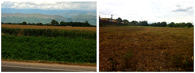
Figure 1. The land-use recognized during the individual’s field visit in the municipality of “El Espinal” (Tolima): sorghum crop (left) and paddock (right).
Ground-truthing Terra-i data
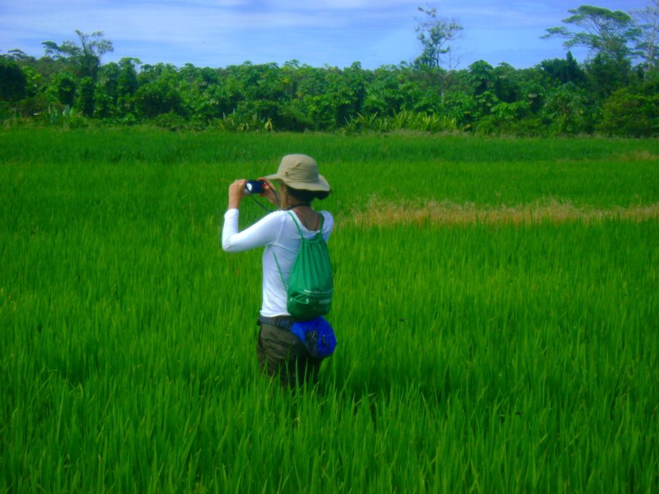
Sergio Cortes, former MSc of the University of Southampton, told the Terra-i team that the aim for his research was to visit two municipalities in Colombia (“Cota” and “El Espinal”), identifying areas of rapid deforestation or land-use change and thus ground-truthing the data from Terra-i (Figure 2).
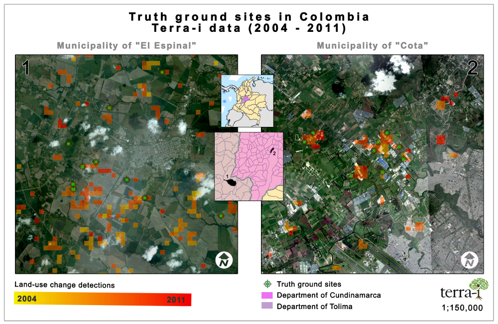
Figure 2. Field sites (green shapes) where Terra-i land-use detections from between 2004-2011 (yellow to red spots) were verified, in the municipalities of El Espinal (Tolima) and Cota (Cundinamarca), Colombia.
He also hoped to establish local drivers of land use change and explore the impact of change on communities in the area. Direct interviews with the communities verified information given by Terra-i about habitat change in those areas.
Verification of transformation
Some fundamental questions that allow to Sergio to introduce issues described in this research were:
- What are the processes leading to the land-use change identified by Terra-i (e.g. forest to agriculture, agriculture to industry, among others)?
- Has Terra-i software correctly identified areas with high rates of deforestation during the last eight years?
- What are the external drivers in the land-use change?
The results
The two sites were characterized by highly fertile soils in addition to a high incidence of industrial activities (Figure 3). The Terra-i data extracted to identify potentially disturbed sites indicated a trend of change from agriculture to industry in one site (Cundinamarca), and intensification of agriculture in the other (Tolima).
Sergio concluded that Terra-i has accurately identified those areas which have undergone land-use transformations in recent years.
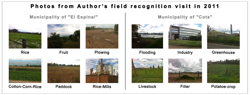
Figure 3. Photos from Sergio’s field work demonstrating the land-use conditions that were found at each site.
How did Terra-i go from the Internet to the individual?
Sergio communicated personally with the Terra-i team after he noticed the tool’s potential through a connection with The ESPA ASSETS (Attaining Sustainable Services from Ecosystems Through Trade-off Scenarios) initiative. Such initiatives—led by a variety of institutions and their host universities--have started to rely on Terra-i data thanks to its time sensitive and highly consistent information, as this case study has shown.
Further information about Sergio’s work can be found on the Terra-i website in the Publications section.
The Terra-i team invites its users to share about further research or initiatives making use of its data.
This article was authored by the members of the Terra-i team. The team is grateful to Sergio for sharing the details of his work as well as the digital version of his thesis. Revision of English-language version by Caitlin Peterson (CIAT / CCAFS visiting researcher).


The Terra-i team together with CRS El Salvador under the Raices project carried out a virtual workshop through the teams platform to technicians from the Ministry of Environment and Natural Resources, CARITAS, Universidad El Salvador, CENTA, about the Mapping of land cover using remote sensors and open source tools such as GEE, SEPAL and QGIS- Plugin Semi Automatic Classification.


Near real-time vegetation loss detection in Southwestern Ethiopia: calibration, validation, and implementation of the Terra-i system


The Alliance of Bioversity International and the International Center for Tropical Agriculture (CIAT) (the Alliance) conducted a training for local stakeholders on the use of Terra-i as part of the collaboration with the Netherlands Development Organisation – SNV in the Coffee Agroforestry and Forest Enhancement for REDD+ (CAFÉ-REDD) Project.


From May 8-12, 2017, the Terra-i team, together with staff from the DGOTA of Peru's Ministry of Environment, carried out the first field validation of vegetative land cover changes detected during Terra-i monitoring for 2016 and 2017, using the technology UAV. This work was carried out under the framework of the project “Sustainable Amazonian Landscapes”. The team carried out over-flights with a Phantom 3 advanced rotor drone and a fixed-wing Ebee drone in seven townships of Yurimaguas. The objective of this work was to recognize the dynamics of land cover and land use changes in the region while at the same time to validate the accuracy of the detections of forest loss being monitored by Terra-i in Yurimaguas.


The Terra-i team has worked hard on renovating Terra-i’s website since early this year. A set of new features on the website provides interactive contents and facilitates adaptation to the mobile devices of our users. The fresh website was developed using the latest update of an open-source, Java-based web system, Magnolia CMS 5.4.4. This update was customized to add different categories of interaction such as news, vegetation cover changes, and information, among others.


Globally more than 1 billion people depend on forests for their livelihoods. Forests play a crucial role in climate regulation, ecosystem services provision and regulation, water supply, carbon storage and many other functions that support biodiversity. Currently the global rate of deforestation is substantial, and there is a growing need for timely, spatially explicit data that flag natural vegetation changes due to human activities.


The latest update of Terra-i has been used with the Co$ting Nature ecosystem services assessment tool to understand the impacts of recent forest loss in Colombia on biodiversity and ecosystem services.

During the 1st and 12th of June 2015, the Terra-i team, together with the Instituto de Investigaciones de la Amazonía Peruana (IIAP) and the Universidad Nacional Agraria La Molina (VLIR-UNALM), conducted the second field validation of the data produced by the Terra-I system. This time, the study area was the Yurimaguas district, Alto Amazonas province, Loreto region (Peru). We used information on populated places, main roads, rivers and information on land cover changes detected for 2013, 2014 and 2015 to define the 65 sampling points (or Terra-I pixels) for the validation process (Figure 1).