View videos
Explore our videos
Habitat change detection in Caquetá, Colombia
 The department of Caquetá is located in the south east of Colombia, bounded to the north by Meta and Guaviare, to the west by Huila and Cauca, to the east by Vaupés and finally by Amazonas and Putumayo to the south.
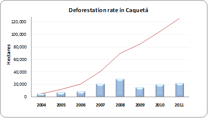
Caquetá’s economy is mainly based on farming (the fourth largest agricultural economy in Colombia) growing crops such as rice, bananas, cassava, corn, palm and sugarcane. Caquetá covers an area of around 90 thousand km2 (9 million hectares). Terra-i has measured an average deforestation rate of 16,778 hectares per year of which 11,442 occurred in the municipality of San Vicente del Caguan. For decades, this large area with diverse flora and fauna has been threatened by the presence of illegal armed groups. Nevertheless, it is now the most important municipality in the Department for livestock and dairy production, as well as being one of the municipalities with the highest timber production.
In Caquetá two areas of great ecological importance are located, the protected national park of Chiribiquete and part of Los Picachos. The Chiribiquete Mountain is composed of dense forests and large savannahs, and is one of the major remaining rocky chains belonging to the Precambrian and Paleozoic formations that are part of the Guiana shield.
Video Request
To request a video, you can fill out the form on the next page